Category:Maps of the Metropolitan Transit Authority (Boston)
Jump to navigation
Jump to search
Media in category "Maps of the Metropolitan Transit Authority (Boston)"
The following 17 files are in this category, out of 17 total.
-
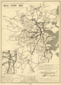
 1948 M.T.A. Boston map.jpg 1,261 × 2,100; 765 KB
-
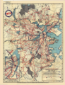
 M.T.A. fare map, circa 1950.png 2,530 × 3,500; 14.56 MB
-
 1950 M.T.A. Boston map.jpg 5,398 × 8,928; 87.06 MB
-
 1950 M.T.A. subway map.png 3,408 × 3,500; 14.17 MB
-
 1952 M.T.A. Boston map.png 3,500 × 4,640; 34.65 MB
-
 1954 M.T.A. Boston map.png 2,691 × 3,500; 21.6 MB
-
 1956 M.T.A. Boston map.png 2,626 × 3,500; 19.48 MB
-
 1956 MTA system map (front).jpg 10,767 × 14,382; 28.52 MB
-
 1956 MTA system map (reverse).jpg 10,798 × 14,412; 27.22 MB
-
 1959 M.T.A. Boston map.png 2,500 × 3,325; 17.27 MB
-
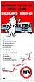 1959 MTA Highland Branch flier.jpg 563 × 1,303; 148 KB
-
 1961 M.T.A. Boston map.png 2,642 × 3,500; 25.79 MB
-
 1961 M.T.A. track map.png 3,500 × 2,708; 9.79 MB
-
 1963 MTA master plan of rapid transit extensions.png 3,500 × 5,369; 38.01 MB
-
 1964 M.T.A. Boston map.png 3,500 × 4,676; 32.31 MB
-
 Boston-Area Trackless Trolleys 1960.svg 2,550 × 3,100; 51 KB
-
 Mettransitauthority MA.svg 1,337 × 1,332; 392 KB


.jpg)
.jpg)


