Category:Maps of the Congo River
Jump to navigation
Jump to search
Subcategories
This category has only the following subcategory.
O
- Old maps of the river Kongo (8 F)
Media in category "Maps of the Congo River"
The following 64 files are in this category, out of 64 total.
-
 (Région du Congo central) - DPLA - 6b6f94f0f27706c748d68ba7561295b0.jpg 1,000 × 610; 217 KB
-
 River Congo-es.svg 496 × 406; 252 KB
-
 River Congo.svg 496 × 406; 400 KB
-
 CuencaDelRíoCongoMapaTopográfico.svg 469 × 391; 78.41 MB
-
 Rio Congo.png 845 × 690; 1.02 MB
-
 Rzeka Kongo.png 845 × 690; 957 KB
-

-

-
 KONGO1877.JPG 6,137 × 5,393; 5.58 MB
-
 DUPONT(1889) pg743 Carte du Congo.jpg 963 × 483; 213 KB
-
 DUPONT(1889) pg745 Carte du Congo.jpg 929 × 843; 408 KB
-
 DUPONT(1889) pg747 Carte du Congo.jpg 911 × 454; 192 KB
-
 DUPONT(1889) pg753 Distributiondes Palmiers.jpg 951 × 717; 388 KB
-
 Rzeka Kongo.jpg 845 × 690; 129 KB
-
 251 of 'Five Years with the Congo Cannibals ... Illustrated, etc' (11204962305).jpg 1,749 × 2,296; 796 KB
-

-
 377 of 'Journal et correspondance ... Publiés par W. G. Barttelot' (11212743175).jpg 2,487 × 2,119; 1.05 MB
-

-

-

-
 68755-Kongo ibaia.svg 134 × 168; 103 KB
-

-
 A new survey of the river Congo - Maxwell - btv1b53177355h.jpg 7,676 × 18,329; 16.4 MB
-

-
 Admiralty Chart No 1013 Africa west coast Cape Lopez to Cape of Good Hope, Published 1887.jpg 8,725 × 15,127; 12.31 MB
-
 Admiralty Chart No 3206 Baie de Loango to Rio Lucunga, Published 1958.jpg 11,335 × 16,371; 42.33 MB
-
 Admiralty Chart No 604 Africa west coast Cape Lopez Bay to St Paul de Loanda, Published 1882.jpg 8,203 × 12,305; 12.03 MB
-

-
 Afrique équatoriale - btv1b53146664b (1 of 3).jpg 5,712 × 4,252; 3.94 MB
-
 Afrique équatoriale - btv1b53146664b (2 of 3).jpg 6,012 × 4,898; 4.2 MB
-
 Afrique équatoriale - btv1b53146664b (3 of 3).jpg 4,266 × 5,282; 3.45 MB
-
 AMH-7956-KB Map of the mouth of the Congo River.jpg 1,723 × 2,400; 594 KB
-
 Angola-DRC boundary. LOC 84692090.jpg 5,721 × 4,136; 2.34 MB
-
 Carte du bassin du Congo.png 9,468 × 6,844; 96.31 MB
-
 Carte du fleuve Congo.jpg 238 × 300; 14 KB
-

-
 Congo map with African ape species.png 723 × 618; 418 KB
-
 Congo names.png 380 × 370; 18 KB
-
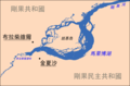
 Stanley pool01.jpg 1,105 × 1,027; 153 KB
-
 Congo Transport Map.PNG 1,129 × 987; 170 KB
-
 Congo-Congo border.jpg 784 × 1,047; 122 KB
-
 Congo-Mubangi-1908.jpg 472 × 760; 89 KB
-
 Conventional Congo Basin - DPLA - 5dbb94c071822e720e92ec7bb62fad5f.jpg 8,874 × 6,236; 6.43 MB
-
 Croquis du fleuve "Congo" de son embouchure à Brazzaville - btv1b53146770b.jpg 5,276 × 3,800; 2.1 MB
-
 CuencaDelRíoCongoMapaTopográfico2.svg 469 × 391; 78.79 MB
-
 Die Gartenlaube (1882) b 784.jpg 1,403 × 2,037; 303 KB
-
 Die Nebenflüsse des Mittleren Congo, Lulongo, Tschuapa, Mobangi u.a.png 4,567 × 3,789; 22.39 MB
-
 EB1911 Congo.png 536 × 641; 127 KB
-
 Embouchure du Kongo-1747.jpg 2,048 × 2,555; 2.72 MB
-
 Exploration Ubangi-Itimbiri.jpg 1,434 × 1,041; 188 KB
-
 Inga-matadi.jpg 337 × 800; 283 KB
-
 Livingstone falls map.jpg 655 × 618; 374 KB
-
 Malaibohu-zh-tw.png 1,667 × 1,098; 138 KB
-

-

-
 Parasite180080-Figure1 Map of sampling localities.png 2,002 × 1,019; 621 KB
-
 PMa B 471 Tervuren.jpg 600 × 382; 234 KB
-
 River Congo svg edited.png 1,251 × 1,024; 361 KB
-

-

-

-
 Svenska missionsförbundets stationer, Nedre Kongo.jpg 1,023 × 610; 103 KB
-
 The American Museum Congo expedition collection of bats (1917) (17538698593).jpg 3,616 × 2,092; 2.03 MB
-

_-_DPLA_-_6b6f94f0f27706c748d68ba7561295b0.jpg)


.jpg)
%27_(11169948865).jpg)

_pg743_Carte_du_Congo.jpg)
_pg745_Carte_du_Congo.jpg)
_pg747_Carte_du_Congo.jpg)
_pg753_Distributiondes_Palmiers.jpg)

.jpg)
%27_(11176110994).jpg)
.jpg)
%27_(11194775805).jpg)
.jpg)
.jpg)

%27_(11198565056).jpg)

_(14777171562).jpg)


.jpg)
.jpg)
.jpg)


_b_784.jpg)


_(17538698593).jpg)
_with_Angola_and_Congo_inset_map_in_1973,_from-_Angola-South-West_Africa_boundary._LOC_84692090_(cropped).jpg)