Category:Maps of the City of York
Jump to navigation
Jump to search
Subcategories
This category has the following 2 subcategories, out of 2 total.
E
Y
Media in category "Maps of the City of York"
The following 13 files are in this category, out of 13 total.
-
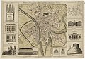
 A Plan of the City of York - Survey'd By Peter Chassereau - btv1b53057193m.jpg 8,468 × 6,142; 9.16 MB
-
 City of York Council election 2011 map.svg 1,376 × 1,345; 383 KB
-
 City of York Council election 2015 map.svg 1,516 × 1,483; 468 KB
-
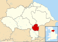
 EnglandYork.png 200 × 247; 26 KB
-
-
 Plan of the city of York - btv1b84390243.jpg 8,098 × 7,387; 7.17 MB
-
 York in England (special marker).svg 816 × 991; 1.32 MB
-
 York in England (zoom).svg 816 × 991; 1.31 MB
-
 York in England.svg 816 × 991; 1.32 MB
-
 York UK locator map (1996-2023).svg 1,425 × 1,037; 1.26 MB
-
 York UK locator map (2023).svg 1,425 × 1,037; 1.11 MB
-
 York UK ward map 2010 (blank).svg 1,376 × 1,345; 382 KB
-
 York UK ward map 2015 (blank).svg 1,376 × 1,345; 461 KB


_d%27York,_capitale_de_le_(sic)_comt%C3%A9_du_m%C3%AAme_nom_-_lev%C3%A9_par_le_Sr_P._Chassereau..._-_btv1b84427466.jpg)

.svg)
.svg)

.svg)
.svg)
.svg)
.svg)