Category:Maps of the Chera Dynasty
Jump to navigation
Jump to search
Media in category "Maps of the Chera Dynasty"
The following 7 files are in this category, out of 7 total.
-
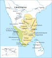
Chera country (early historic south India).jpg 2,670 × 2,219; 878 KB
-
Chera kingdom chieftaincies and Chola mandalams c 11th century-es.svg 1,648 × 1,846; 2.17 MB
-
Chera kingdom, chieftaincies, and Chola mandalams c. 11th century (zoom).svg 3,000 × 2,650; 184 KB
-
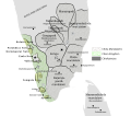
Chera kingdom, chieftaincies, and Chola mandalams c. 11th century.svg 2,205 × 2,982; 186 KB
-
Chera kingdom, chieftaincies, c. 11th century.svg 1,240 × 1,650; 185 KB
-
Chera territoriesa.png 270 × 143; 10 KB
-
Map of Chera Country.jpg 2,670 × 2,219; 890 KB


