Category:Maps of the 2017 UK general election (by constituency)
Jump to navigation
Jump to search
Media in category "Maps of the 2017 UK general election (by constituency)"
The following 21 files are in this category, out of 21 total.
-
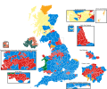
2017 UK Election map England.svg 1,500 × 1,200; 6.29 MB
-
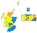
2017 UK election map Scotland.svg 809 × 716; 945 KB
-
2017 UK general election constituency map.svg 1,477 × 1,925; 97 KB
-
2017 UK General Election map.svg 3,257 × 6,060; 3.75 MB
-
2017 UK General Election Winner%.svg 512 × 426; 6.05 MB
-
2017UKElectionMap votes.svg 1,020 × 996; 7.53 MB
-
2017UKElectionMap.svg 1,248 × 1,039; 5.36 MB
-
2017UKelectionMapScotland cy.svg 809 × 716; 950 KB
-
2017UKelectionMapScotland.svg 809 × 716; 950 KB
-
Bristol UK general election 2017 map.svg 1,138 × 1,266; 597 KB
-
Jun2017MPsEngland.png 1,142 × 707; 3.09 MB
-
LondonParliamentaryConstituency2017Results.svg 427 × 337; 615 KB
-
MerseysideParliamentaryConstituency2017Results.svg 301 × 311; 59 KB
-
Minor party only UK 2017.png 2,000 × 2,607; 705 KB
-
Northern Ireland election seats 1997-2017.svg 1,400 × 710; 189 KB
-
SouthYorkshireParliamentaryConstituency2017Results.svg 319 × 210; 173 KB
-
United Kingdom general election, 2017 (Northern Ireland).svg 779 × 635; 136 KB


