Category:Maps of rivers of Morbihan
Jump to navigation
Jump to search
Departments of Metropolitan France: Ain [01] · Aisne [02] · Alpes-de-Haute-Provence [04] · Hautes-Alpes [05] · Ardèche [07] · Ariège [09] · Aube [10] · Aude [11] · Aveyron [12] · Bouches-du-Rhône [13] · Calvados [14] · Cantal [15] · Charente-Maritime [17] · Cher [18] · Corrèze [19] · Corse-du-Sud [2A]† · Haute-Corse [2B]† · Côte-d’Or [21] · Creuse [23] · Drôme [26] · Eure-et-Loir [28] · Finistère [29] · Gard [30] · Haute-Garonne [31] · Gers [32] · Gironde [33] · Hérault [34] · Ille-et-Vilaine [35] · Indre [36] · Indre-et-Loire [37] · Isère [38] · Jura [39] · Landes [40] · Loir-et-Cher [41] · Loire [42] · Haute-Loire [43] · Loire-Atlantique [44] · Loiret [45] · Lot [46] · Lot-et-Garonne [47] · Lozère [48] · Maine-et-Loire [49] · Manche [50] · Marne [51] · Haute-Marne [52] · Mayenne [53] · Meurthe-et-Moselle [54] · Morbihan [56] · Oise [60] · Pas-de-Calais [62] · Puy-de-Dôme [63] · Pyrénées-Atlantiques [64] · Hautes-Pyrénées [65] · Pyrénées-Orientales [66] · Haute-Saône [70] · Saône-et-Loire [71] · Sarthe [72] · Haute-Savoie [74] · Seine-Maritime [76] · Seine-et-Marne [77] · Yvelines [78] · Var [83] · Territoire de Belfort [90] · Val-d'Oise [95]
Media in category "Maps of rivers of Morbihan"
The following 22 files are in this category, out of 22 total.
-
 56-Cours eau 50km.jpg 3,507 × 2,480; 699 KB
-
 56-Cours eau.jpg 3,507 × 2,480; 1.39 MB
-
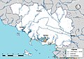
 Aff OSM.png 461 × 600; 556 KB
-
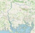
 Arz (rivière) OSM.png 884 × 347; 626 KB
-
 Aër cours d'eau.png 881 × 671; 343 KB
-
 Brandifrout carte topo.png 867 × 696; 603 KB
-
 Carte rivière d'Etel.svg 1,242 × 907; 75 KB
-
 Coet Organ carte topo.png 896 × 775; 677 KB
-
 Ellé cours d'eau.png 737 × 599; 865 KB
-
 Evel cours d'eau.png 1,247 × 676; 518 KB
-
 Houé carte topo.png 938 × 715; 683 KB
-
 Inam cours d'eau.png 867 × 806; 397 KB
-
 Langonnet cours d'eau.png 1,061 × 1,050; 786 KB
-
 Loc'h cours d'eau.png 1,186 × 1,141; 1.55 MB
-
 Moulin du Duc cours d'eau.png 1,134 × 1,112; 899 KB
-
 Naïc cours d'eau.png 1,416 × 879; 468 KB
-
 Naïc opentopomap.png 1,736 × 1,369; 3.52 MB
-
 Rade de Lorient road map-fr.svg 2,296 × 2,018; 1.19 MB
-
 Ruisseau de Kerustang cours d'eau.png 767 × 623; 284 KB
-
 Saint Sauveur carte topo.png 1,113 × 872; 962 KB
-
 Sarre cours d'eau.png 876 × 895; 460 KB
-
 Stang Hingant cours d'eau.png 1,209 × 887; 385 KB


_OSM.png)