Category:Maps of ranchos of Los Angeles County, California
Jump to navigation
Jump to search
Media in category "Maps of ranchos of Los Angeles County, California"
The following 98 files are in this category, out of 98 total.
-
1920 United States survey of Rancho Potrero Chico 01.jpg 2,745 × 1,802; 586 KB
-
1920 United States survey of Rancho Potrero Chico 02.pdf 1,814 × 2,695, 3 pages; 242 KB
-
Bancroft collection diseño diseno map of Rancho Temescal.jpg 513 × 687; 119 KB
-
Bancroft UC Berkeley diseño 1846 Rancho Santa Gertrudes California.jpg 689 × 508; 125 KB
-
CA State Archives 1852 Diseno Diseño Del Rancho La Cañada Canada de Los Nogales.jpg 3,227 × 3,227; 2.68 MB
-
CALISPHERE 1850 Diseño del Rancho Providencia diseno map.jpg 686 × 519; 127 KB
-
CALISPHERE plat of Rancho Santa Gertrudes 1868.jpg 999 × 666; 155 KB
-
CLAREMONT Rancho San Pedro survey map 1857.jpg 2,649 × 2,048; 1.17 MB
-
Crop LMU collections Hancock survey of Rancho San Pedro 1859.jpg 2,754 × 2,754; 3.17 MB
-
CSUMB Digital Commons Diseño diseno map Rancho San Jose de Buenos Ayres.jpg 1,777 × 1,269; 819 KB
-
CSUMB Digital Commons Diseño diseno Rancho San Francisquito Dalton Los Angeles.jpg 1,340 × 1,340; 565 KB
-
CSUMB digital commons plan Diseño Rancho San Antonio LUGO California Los Angeles.jpg 2,204 × 1,772; 1.39 MB
-
CSUMB Digital Commons Rancho La Brea diseño Diseno map.jpg 664 × 407; 94 KB
-
CSUMB Digital Commons Rancho Tujunga diseño diseño map.jpg 1,378 × 1,686; 1,004 KB
-
CSUMB Digital Commons survey map of Rancho El Escorpion 1896 General Land Office 02.png 2,552 × 1,963; 10.05 MB
-
CSUMB Diseño Rancho La Merced 1854 California Los Angeles ranchos.jpg 2,370 × 1,485; 1.17 MB
-
CSUN Digital - Title Map of Rancho el Encino, 1873.jpg 1,148 × 1,778; 297 KB
-
Diseño de Rancho San Pedro Los Angeles California Dominguez 1843.jpg 2,263 × 1,721; 1.3 MB
-
Diseño del Rancho Castec 1854 Castaic California Kern Los Angeles.jpg 1,677 × 2,005; 960 KB
-
Diseño Del Rancho de la Puenta California Rancho La Puente map 1842.jpg 2,371 × 1,872; 1.66 MB
-
Diseño del Rancho La Ciénega ó Paso de la Tijera (Los Angeles County, California).jpg 1,506 × 1,171; 569 KB
-
Diseño del Rancho Las Vírgenes 1853.jpg 1,326 × 969; 477 KB
-
Diseño Del Rancho Los Nogales Los Angeles County California.jpg 1,449 × 2,129; 1.01 MB
-
Diseño Del Rancho Paso de Bartolo Viejo 1852-10-04.jpg 1,881 × 2,292; 1.33 MB
-
Diseño Del Rancho Potrero de Felipe Lugo 1853 California Los Angeles County.jpg 1,321 × 1,344; 665 KB
-
Diseño Del Rancho Potrero Grande 1854 Los Angeles County California.jpg 1,468 × 956; 515 KB
-
Diseño del Rancho Rincón de la Brea.jpg 490 × 649; 87 KB
-
Diseño Del Rancho Rosa Castilla.jpg 999 × 999; 187 KB
-
Diseño Del Rancho Tajuata 1852 California Los Angeles.jpg 2,290 × 1,431; 1.1 MB
-
Diseño of Rancho La Habra California Los Angeles Juan Jose Nieto la Cañada de la Habra.jpg 2,177 × 1,716; 1.32 MB
-
Eagle Tree on 1859 U.S. government survey of Rancho San Pedro.jpg 750 × 1,155; 754 KB
-
Henry Hancock 1860 U.S. Survey map of Rancho Los Nogales Walnut Los Angeles.jpg 4,183 × 5,229; 5.05 MB
-
Huntington 1858 survey map of Los Angeles rancho San Jose de Buenos Ayres.jpg 6,373 × 5,781; 10.43 MB
-
HUNTINGTON 1858 Title Plat of the Ranchos Azusa and San José.jpg 1,889 × 1,471; 555 KB
-
Huntington 1866 plat survey map Rancho San Francisquito Dalton Los Angeles County.jpg 5,601 × 3,032; 4.28 MB
-
HUNTINGTON 1868 Survey Rancho Cienega o Paso de la Tijera.jpg 2,420 × 2,420; 1.06 MB
-
HUNTINGTON 1885 Map of that part of the Rancho San Pedro allotted to Manuel Dominguez.jpg 7,961 × 6,470; 10.03 MB
-
HUNTINGTON 1891 Plat survey map of Rancho Paso de Bartolo.jpg 7,206 × 5,883; 10.35 MB
-
Huntington Library 1868 survey map of Rancho Tujunga.jpg 5,550 × 3,122; 3 MB
-
Huntington Library collection Rancho Sausal Redondo US survey plat map.jpg 6,202 × 5,285; 5.1 MB
-
Huntington Library map Rancho El Escorpión 1862 survey.jpg 3,145 × 4,602; 1.94 MB
-
Huntington Library Rancho La Ballona Plat survey 1867ish.jpg 8,500 × 5,863; 13.59 MB
-
Huntington Library SR Map 0132 Rancho Rodeo de las Aguas 1868 plat map.jpg 1,249 × 1,166; 425 KB
-
Huntington Library US Surveyor map of Rancho El Conejo possibly 1856.jpg 1,539 × 1,114; 394 KB
-
Huntington Museum Map Collection 1888 Rancho Simi Land and Water map.jpg 8,597 × 6,116; 8.98 MB
-
Huntington plat 1857 Cuati Victoria Reid.jpg 3,714 × 5,982; 4.22 MB
-
Huntington Solano-Reeve 1850s or 1860s Survey map of Ranchos Providencia y Cahuenga.jpg 5,072 × 5,072; 3.4 MB
-
Huntington Solano-Reeve 1858 Rancho Los Alamitos survey map.jpg 7,291 × 4,183; 5.24 MB
-
HUNTINGTON Solano-Reeve 1874-11-20 Map of Rincon Denis Bear.jpg 7,645 × 8,551; 11.96 MB
-
HUNTINGTON SOLANO-REEVE Rancho Los Cerritos circa 1870 official survey plat by Henry Hancock.jpg 5,592 × 9,043; 10.21 MB
-
HUNTINGTON SOLANO-REEVE Rancho Potrero Grande survey map undated.jpg 8,293 × 4,664; 6.73 MB
-
Huntington SR Box 20(01).04.jpg 3,623 × 5,665; 2.65 MB
-
Huntington SR Box 21(07).01 Rancho Encino San Fernando Valley 1868 survey.jpg 3,786 × 5,214; 3.74 MB
-
Huntington SR Box 25(10).03 Rancho La Ballona 1858.jpg 4,737 × 4,737; 5.93 MB
-
Los Angeles City Lands, Diseños 422, GLO No. 427, Los Angeles County.jpg 1,410 × 2,509; 1.01 MB
-
Map of Rancho San Jose and Pomona created after 1922.jpg 3,770 × 5,704; 6.9 MB
-
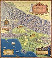
Photos 2881 large WPA Federal Writers' Project map of ranchos of Los Angeles County California.jpg 10,743 × 6,898; 18.67 MB
-
Rancho Azusa de Dalton diseño 1 of 4 produced CSUMB digital commons.jpg 2,442 × 1,668; 1.29 MB
-
Rancho El Conejo diseño California southern.jpg 2,445 × 1,629; 1.45 MB
-
Rancho El Encino 1871.jpg 1,980 × 1,980; 714 KB
-
RANCHO EX MISSION SAN FERNANDO Huntington Solano-Reeve 1871 SURVEY PLAT handcolored 1897.jpg 9,663 × 8,013; 13.2 MB
-
RANCHO LA BREA survey map BLM Survey, Apr. 7, 1873, La Brea, GLO 429.jpg 1,463 × 1,463; 957 KB
-
Rancho La Cañada 1852 diseño diseno La Cañada Flintridge Los Angeles County California.jpg 2,520 × 1,707; 1.25 MB
-
Rancho Los Coyotes Southern California survey map.jpg 8,228 × 7,002; 8.31 MB
-
Rancho San Pasqual Los Angeles diseño 1843 BANCROFT.jpg 703 × 583; 123 KB
-
Rancho San Vicente Y Santa Monica (cropped).png 1,661 × 1,198; 1.92 MB
-
Rancho Topanga Malibu Sequit survey map maybe around 1900 Huntington Museum collection.jpg 5,945 × 3,818; 4.92 MB
-
Ranchos Providencia y Cahuenga U.S. survey map California land grant 01.jpg 1,528 × 1,528; 793 KB
-
Ranchos Providencia y Cahuenga U.S. survey map California land grant 02.jpg 1,487 × 1,487; 685 KB
-
Ranchos Providencia y Cahuenga U.S. survey map California land grant 03.png 2,474 × 2,001; 8.79 MB
-
Ranchos Providencia y Cahuenga U.S. survey map California land grant 04.png 2,370 × 2,090; 9.11 MB
-
Ranchos Providencia y Cahuenga U.S. survey map California land grant 05.pdf 3,993 × 3,520; 8.18 MB
-
Ranchos Providencia y Cahuenga U.S. survey map California land grant 06.pdf 4,264 × 3,450; 8.56 MB
-
RUDERMAN 1868 Rancho La Puente survey.jpg 1,580 × 952; 607 KB
-
Ruderman Rare Maps Southern Pacific Rancho San Antonio before 1903.jpg 726 × 726; 223 KB
-
Subdivision of the Rancho Paso de Portolo formerly confirmed to Don Pio Pico.jpg 1,600 × 1,205; 500 KB
-
Survey map of the Rancho San Francisco in Los Angeles and Kern County 01.png 1,804 × 2,784; 1.15 MB
-
Survey map of the Rancho San Francisco in Los Angeles and Kern County 02.png 1,813 × 2,750; 1.03 MB
-
UC Berkeley Bancroft collection Rancho Simi diseño diseno map.jpg 701 × 502; 130 KB
-
UCLA Rudman Collection 1888 map of Rancho San Jose irrigation survey.jpg 6,727 × 10,624; 22.81 MB


