Category:Maps of national parks of Norway
Jump to navigation
Jump to search
Subcategories
This category has only the following subcategory.
Media in category "Maps of national parks of Norway"
The following 26 files are in this category, out of 26 total.
-
Fulufjellet National Park map.svg 1,052 × 1,488; 6.7 MB
-
Fulufjället National Park topographic map-fr.svg 2,274 × 3,938; 1.57 MB
-
Indre Wijdefjorden National Park locator map.svg 2,208 × 2,821; 971 KB
-
Indre Wijdefjorden National Park map.svg 672 × 1,005; 10.71 MB
-
Kosterhavet Ytre Hvaler National Park topographic map-fr.svg 1,625 × 2,336; 4.37 MB
-
Kosterhavet Ytre Hvaler National Park topographic map-sv.svg 1,625 × 2,336; 4.36 MB
-
Map Protected Areas Ostfold.png 550 × 645; 75 KB
-
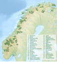
Nasjonalparker i Norge.svg 1,772 × 1,882; 3.04 MB
-
Nasjonalparker Nord-Norge ny-2.jpg 820 × 725; 73 KB
-
Nasjonalparker Norge ny-2.jpg 489 × 599; 36 KB
-
Nasjonalparker Norge ny-3.jpg 489 × 599; 32 KB
-
Nasjonalparker Svalbard.JPG 1,000 × 1,069; 306 KB
-
Nasjonalparker Syd-Norge ny.jpg 657 × 965; 88 KB
-
Nordenskiöld Land National Park locator map.svg 2,208 × 2,821; 971 KB
-
Nordre Isfjorden National Park locator map.svg 2,208 × 2,821; 971 KB
-
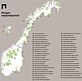
Norske nasjonalparker kart.jpg 960 × 940; 94 KB
-
Oversikt-over-norges-nasjonalparker 2018.svg 1,548 × 1,178; 2.39 MB
-
Rohkunborri National Park map.svg 1,488 × 1,052; 11.39 MB
-
Sassen-Bünsow Land National Park locator map.svg 2,208 × 2,821; 971 KB
-
Svalbard protected areas map 1973.svg 2,208 × 2,821; 943 KB
-
Svalbard protected areas map with names LV.svg 512 × 654; 424 KB
-
Svalbard protected areas map with names.svg 2,208 × 2,821; 1.01 MB
-
Svalbard protected areas map.svg 2,208 × 2,821; 971 KB
-
Sør-Spitsbergen National Park locator map.svg 2,208 × 2,821; 971 KB
-
Verneomraader Svalbard.jpg 1,000 × 1,069; 137 KB
-
Øvre Pasvik National Park map.svg 659 × 907; 1,019 KB


