Category:Maps of caves in France
Jump to navigation
Jump to search
Subcategories
This category has the following 5 subcategories, out of 5 total.
- Maps of caves in Ariège (1 F)
- Maps of caves in Doubs (1 F)
- Maps of caves in Lozère (2 F)
M
- Maps of caves in Isère (4 F)
Media in category "Maps of caves in France"
The following 27 files are in this category, out of 27 total.
-
 Baume des Pierres.jpg 2,413 × 1,980; 1.03 MB
-
 Baume Murade Topographie mod.jpg 1,294 × 1,515; 419 KB
-
 Brotschgrotte topomod.jpg 1,854 × 1,205; 502 KB
-
 Brumes matinales et vallon.jpg 1,464 × 1,976; 450 KB
-
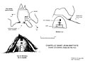 Chapelle Saint Jean Baptiste topo mod.jpg 2,901 × 2,100; 811 KB
-
 Cosquerova jeskyne.png 639 × 545; 76 KB
-
 Daluis Chat.jpg 2,220 × 2,991; 898 KB
-
 Franco-Cantabrian region Altamira.gif 956 × 482; 21 KB
-
 Franco-Cantabrian region.gif 956 × 482; 21 KB
-
 Grotte des Druides topomod.jpg 1,474 × 1,164; 458 KB
-
 Grotte des Fees de Chatelperron mod.jpg 2,173 × 1,534; 1.15 MB
-
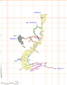
 Grotte du Trou-Madame Topo mod.jpg 1,701 × 2,085; 328 KB
-
 Grotte Théophile 1.jpg bis.jpg 4,289 × 2,272; 726 KB
-
 Grotte-Heloise-topomod.jpg 1,417 × 1,731; 484 KB
-
 Grottes-des-Eglises-mod.jpg 1,417 × 876; 1.29 MB
-
 Lascaux plan-ru.JPG 540 × 720; 57 KB
-
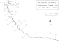
 Pertes de l Aure Maisons Cad Nap.jpg 1,422 × 774; 83 KB
-
 Plan de la grotte de Sainte Araille.png 2,000 × 2,520; 715 KB
-

-

-

-
 Plan schema gouffre vitarelles.gif 582 × 414; 5 KB
-
 Premier relevé de la grotte de Thouzon 1902.jpg 3,000 × 2,983; 565 KB
-
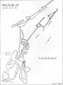
 Théophile noir.jpg 4,036 × 2,266; 740 KB
-
 Trou de Saint Pons Topo mod.jpg 1,692 × 2,298; 533 KB
-
 Villars Plan.jpg 4,182 × 3,196; 603 KB
-
 Villars Plan.png 4,182 × 3,196; 608 KB


_publi%C3%A9_par_E.-A._Martel_en_1894_dans_%22Les_ab%C3%AEmes%22_(1894).png)
_publi%C3%A9_par_N._Husson_en_1863.jpg)


