Category:Maps of archeological sites in Mexico
Jump to navigation
Jump to search
Subcategories
This category has only the following subcategory.
M
Media in category "Maps of archeological sites in Mexico"
The following 29 files are in this category, out of 29 total.
-
 A de S in Early Classic.jpg 1,263 × 1,625; 117 KB
-
 A de S in Early Plancha.jpg 1,200 × 1,311; 90 KB
-
 A de S in Terminal Plancha.jpg 1,359 × 1,411; 101 KB
-
 An abbreviated map of El Tajin.JPG 581 × 833; 123 KB
-
 Detail plan of Xochicalco.JPG 586 × 611; 102 KB
-
 El Ixtépete planta arquitectónica de la última etapa. .jpg 814 × 962; 99 KB
-
 Image of Altar de Sacrificios,GroupA,Late Pasion Phase.jpg 2,157 × 1,200; 236 KB
-
 La Venta site plan.png 1,241 × 1,447; 228 KB
-
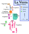 La Venta térképe.png 1,241 × 1,447; 187 KB
-
 Late Pasion,7th Century.jpg 1,468 × 1,720; 131 KB
-
 Late Pasion,8th Century.jpg 1,395 × 1,511; 119 KB
-
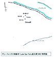 Late San Felix.jpg 1,073 × 1,218; 76 KB
-
 Monte Albán Mapa.jpg 1,264 × 735; 643 KB
-
 Plano de Monte Albán.svg 762 × 762; 428 KB
-
 Plano General Detallado.jpg 1,257 × 824; 222 KB
-
 Plano La Venta.svg 765 × 990; 38 KB
-
 Planta Piramide de la Luna.jpg 1,387 × 1,179; 172 KB
-
 Río Bec.jpg 4,282 × 2,974; 527 KB
-
 Sayil Palacio Plan EN.png 2,250 × 1,700; 459 KB
-
 Sayil Palacio Plan.png 3,000 × 2,200; 526 KB
-
 Sayil Sur plan.jpg 1,151 × 1,015; 63 KB
-
 Sta Rosa Xtampak Pal Plan.jpg 6,487 × 4,457; 1.15 MB
-
 Sta Rosa Xtampak Plan.jpg 5,235 × 3,522; 885 KB
-
 Sta Rosa Xtampak Plan.png 3,000 × 2,018; 787 KB
-
 Tres Zapotes site plan.svg 536 × 595; 198 KB
-
 Tula.png 1,059 × 749; 98 KB
-
 Uxmal Plan2.jpg 5,735 × 9,797; 3.73 MB
-
 Xkichmook Maler Map.jpg 3,005 × 4,357; 3.6 MB
-
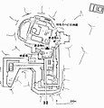
 アルタル・デ・サクリフィシオスGroupAの北側からの想像図.jpg 2,126 × 1,131; 262 KB


