Category:Maps of administrative divisions of Ecuador by User:Milenioscuro
Jump to navigation
Jump to search
Subcategories
This category has only the following subcategory.
Media in category "Maps of administrative divisions of Ecuador by User:Milenioscuro"
The following 24 files are in this category, out of 24 total.
-
 Ecuador Azuay province.svg 1,536 × 1,654; 720 KB
-
 Ecuador Bolivar province.svg 1,536 × 1,654; 720 KB
-
 Ecuador Carchi province.svg 1,536 × 1,654; 721 KB
-
 Ecuador Cañar province.svg 1,536 × 1,654; 721 KB
-
 Ecuador Chimborazo province.svg 1,536 × 1,654; 721 KB
-
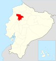
 Ecuador Cotopaxi province.svg 1,536 × 1,654; 721 KB
-
 Ecuador El Oro province.svg 1,536 × 1,654; 721 KB
-
 Ecuador Esmeraldas province.svg 1,536 × 1,654; 721 KB
-
 Ecuador Galapagos province.svg 1,536 × 1,654; 722 KB
-
 Ecuador Guayas province.svg 1,536 × 1,654; 722 KB
-
 Ecuador Imbabura province.svg 1,536 × 1,654; 721 KB
-
 Ecuador Loja province.svg 1,536 × 1,654; 721 KB
-
 Ecuador Los Rios province.svg 1,536 × 1,654; 721 KB
-
 Ecuador Manabi province.svg 1,536 × 1,654; 721 KB
-
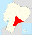 Ecuador Morona Santiago province.svg 1,536 × 1,654; 721 KB
-
 Ecuador Napo province.svg 1,536 × 1,654; 721 KB
-
 Ecuador Orellana province.svg 1,536 × 1,654; 721 KB
-
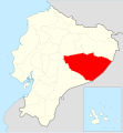 Ecuador Pastaza province.svg 1,536 × 1,654; 721 KB
-
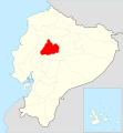
 Ecuador Pichincha province.svg 1,536 × 1,654; 721 KB
-
 Ecuador Santa Elena province.svg 1,536 × 1,654; 721 KB
-
 Ecuador Santo Domingo province.svg 1,536 × 1,654; 721 KB
-
 Ecuador Sucumbíos province.svg 1,536 × 1,654; 721 KB
-
 Ecuador Tungurahua province.svg 1,536 × 1,654; 721 KB
-
 Ecuador Zamora Chinchipe province.svg 1,536 × 1,654; 721 KB


