Category:Maps of Wales in the 10th century
Jump to navigation
Jump to search
English: This category is about the subject of  Wales 901-1000 CE: History maps showing all or a substantial part of the territory of Wales as it was in the 10th century.
Contemporary old maps belong into: Category:Old maps of Wales and its subcategories.
Contemporary old maps belong into: Category:Old maps of Wales and its subcategories.
Media in category "Maps of Wales in the 10th century"
This category contains only the following file.
-
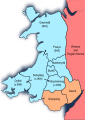 Wales 900-950 (Hywel the Good).svg 744 × 1,052; 512 KB
.svg)