Category:Maps of Sheffield
Jump to navigation
Jump to search
Subcategories
This category has the following 3 subcategories, out of 3 total.
M
P
Media in category "Maps of Sheffield"
The following 23 files are in this category, out of 23 total.
-
 2022 Sheffield City Council election.svg 2,202 × 1,099; 233 KB
-
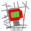 Bramall Lane football ground - plan.png 600 × 600; 31 KB
-
 Church Street map.jpg 2,895 × 1,309; 124 KB
-
 Ecclesfield Open Street Map.svg 1,323 × 1,126; 1.31 MB
-
 Gleadless Valley OSM.png 721 × 790; 186 KB
-
 Hinduism Sheffield 2011 census.png 25,406 × 17,611; 13.14 MB
-
 Indian Sheffield 2011 census.png 25,406 × 17,611; 13.24 MB
-
 Leopold Square, Sheffield - plan.png 1,000 × 1,000; 39 KB
-
 Map of Sheffield Local Election Results 2024.gif 512 × 320; 8 KB
-
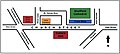
 Sheaf Square - plan - 2002.png 548 × 718; 32 KB
-
 Sheaf Square - plan - 2006.png 548 × 718; 20 KB
-
 Sheaf Square OSM.png 459 × 307; 53 KB
-
 Sheffield City Region map.svg 1,108 × 1,345; 502 KB
-
 Sheffield City Road Cemetery - key.png 497 × 150; 7 KB
-
 Sheffield City Road Cemetery - plan.png 497 × 426; 9 KB
-
 Sheffield General Cemetery - key.png 614 × 200; 12 KB
-
 Sheffield General Cemetery - plan.png 614 × 396; 13 KB
-
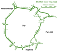 Sheffield inner ring-road.png 900 × 800; 23 KB
-
 Sheffield outer ring-road.png 700 × 1,000; 18 KB
-
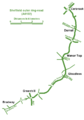
 Sheffield Parkway - plan.png 750 × 350; 19 KB
-
 Sheffield UK ward map 2024.svg 1,425 × 996; 683 KB
-
 Sheffield unparished area UK locator map.svg 1,425 × 996; 415 KB
-
 SheffieldUrbanArea.svg 712 × 615; 125 KB


