Category:Maps of Schaerbeek
Jump to navigation
Jump to search
Wikimedia category | |||||
| Upload media | |||||
| Instance of | |||||
|---|---|---|---|---|---|
| Category combines topics | |||||
| Schaerbeek | |||||
municipality in the Brussels-Capital Region, Belgium _-_2264-0007-0.jpg) Stadshuset i Schaarbeek    Kommunens läge i Brysselregionen. | |||||
| Instance of | |||||
| Part of |
| ||||
| Location | Arrondissement of Brussels-Capital, Brussels-Capital Region, Brussels, Coop of Brussels, Duchy of Brabant | ||||
| Official language | |||||
| Head of government |
| ||||
| Legal form |
| ||||
| Inception |
| ||||
| Population |
| ||||
| Area |
| ||||
| official website | |||||
 | |||||
Media in category "Maps of Schaerbeek"
The following 16 files are in this category, out of 16 total.
-
 Bruxelles Schaerbeek Quartier Dailly affectation du sol 2008.png 1,024 × 654; 35 KB
-
 Bruxelles Schaerbeek Quartier Dailly gris avec numero.gif 1,024 × 654; 20 KB
-
 Bruxelles Schaerbeek Quartier Dailly gris.gif 1,024 × 654; 17 KB
-
 Bruxelles Schaerbeek Quartier Dailly sous divisions vert jaune bleu.png 1,024 × 654; 16 KB
-
 Bruxelles-Capitale Schaerbeek.svg 868 × 843; 22 KB
-
 Evere-Ferraris.png 1,202 × 1,310; 3.08 MB
-
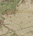
 Ferraris Brussels.jpg 1,271 × 1,016; 381 KB
-
 Ferraris Evere.jpg 680 × 488; 137 KB
-
 Laeken 1891 200.jpg 1,545 × 1,911; 3.48 MB
-
 Map of schaarbeek in belgium.PNG 399 × 335; 8 KB
-
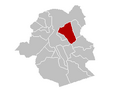 SchaarbeekLocatie.png 270 × 203; 3 KB
-
 Schaerbeek Brussels-Capital Belgium Map.svg 745 × 741; 425 KB
-
 Schaerbeek OSM 01.png 658 × 541; 387 KB
-
 Schaerbeek OSM 02.png 656 × 702; 689 KB
-
 Schaerbeek OSM 03.png 656 × 702; 498 KB
-
 Walckiers-Ferraris.png 638 × 484; 699 KB


