<nowiki>Category:Maps of Reading, Berkshire; विकिमिडिया श्रेणी; kategori Wikimedia; Wikimedia category; د ويکيمېډيا وېشنيزه; Vikimedya kategorisi; ویکیمیڈیا زمرہ; kategória projektov Wikimedia; категорія проєкту Вікімедіа; 维基媒体分类; Wikimedia-Kategorie; ৱিকিমিডিয়াৰ শ্ৰেণী; Викимедиина категорија; Wikimedia-Kategorie; विकिपीडिया:श्रेणी; page de catégorie de Wikimedia; kategorija na Wikimediji; विकिपीडिया वर्ग; категорија на Викимедији; Wikimedia-Kategorie; Wikimedia-kategori; kategori Wikimédia; تصنيف ويكيميديا; pajenn rummata eus Wikimedia; Wikimedia:ကဏ္ဍခွဲခြင်း; 維基媒體分類; Wikimedia категориясы; categoría de Wikimedia; Wikimedia-Kategorie; Wikimedia-Kategorie; tudalen categori Wikimedia; Viciméid catagóir; Վիքիմեդիայի նախագծի կատեգորիա; 维基媒体分类; Wikimedia-kategory; ვიკიპედია:კატეგორიზაცია; ウィキメディアのカテゴリ; categoria Wikimedia; تصنيف بتاع ويكيميديا; විකිමීඩියා ප්රභේද පිටුව; categoria Vicimediorum; विकिमीडिया श्रेणी; Wikimedia-luokka; Wikimedia category; guruhi Vikimedia; катэгорыя ў праекце Вікімэдыя; Викимедиа проектындагы төркем; catigurìa di nu pruggettu Wikimedia; หน้าหมวดหมู่วิกิมีเดีย; Wikimedia:Kategorija; Wikimedia-Kategorie; Wikimedia:Klassys; категория на Уикимедия; categorie a unui proiect Wikimedia; 維基媒體分類; Wikimedia-kategori; kawan Wikimèdia; 維基媒體分類; 위키미디어 분류; Wikimedia-bólkur; kategorio en Vikimedio; kategori Wikimedia; categoría de Wikimedia; উইকিমিডিয়া বিষয়শ্রেণী; kategori Wikimedia; 维基媒体分类; וויקימעדיע קאַטעגאָריע; kategorija w projektach Wikimedije; thể loại Wikimedia; Wikimedia projekta kategorija; kategoria ti Wikimedia; categoria de um projeto da Wikimedia; 维基媒体分类; категорияд Ангилал; Wikimedia-kategori; kategori Wikimedia; پۆلی ویکیمیدیا; Wikimedia category; Vikimédia ñemohenda; Wikimédia-kategória; વિકિપીડિયા શ્રેણી; Wikimediako kategoria; категория в проекте Викимедиа; Wikimedia-Kategorie; Kategoriya ning Wikimedia; Wikimedia-kategorie; Wîkîmediya:Kategorî; विकिमिडिया श्रेणी; Wikimedia-Kategorie; קטגוריה במיזמי ויקימדיה; Викимедиа проектындагы төркем; kategoria w projekcie Wikimedia; κατηγορία εγχειρημάτων Wikimedia; categoría de Wikimedia; Wikimedia-kategoriija; гурӯҳи Викимедиа; categoria de Wikimedia; Wikimedia-categorie; Wikimedia-kategori; categoria di un progetto Wikimedia; Wikimedia-categorie; Vikipidiya:Shopni; Викимедиа категорияһы; Wikimedia kategooria; categurìa 'e nu pruggette Wikimedia; Wikimedia-categorie; kategorya ng Wikimedia; катэгорыя ў праекце Вікімедыя; ẹ̀ka Wikimedia; гурӯҳи Викимедиа; categoria de um projeto da Wikimedia; kategorie na projektech Wikimedia; kategorija na Wikimediji; tumbung Wikimedia; 維基媒體分類; kategorija Wikimedie; Wikimedia proyektındağı törkem; Wikimedia category; Wikimedia-kategorie; kategori Wikimedia; jamii ya Wikimedia; വിക്കിമീഡിയ വർഗ്ഗം; 維基媒體分類; kategori Wikimedia; விக்கிமீடியப் பகுப்பு; زمرو:وڪيپيڊيا زمرا بندي; ردهٔ ویکیپدیا; categoría de Wikimedia; kategori e Wikimedias; 维基媒体分类; Wikimedia:Ronnaghys</nowiki>
Subcategories
This category has the following 2 subcategories, out of 2 total.


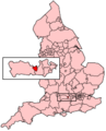 EnglandReading.png 200 × 247; 31 KB
 Location map United Kingdom Reading Central.png 1,134 × 1,209; 847 KB
 Location map United Kingdom Reading.png 1,425 × 1,019; 1.34 MB
 Location of Copa Reading.jpg 575 × 505; 240 KB
 Map of Reading in Berkshire, United Kingdom.png 800 × 434; 182 KB
 Reading in England (special marker).svg 816 × 991; 1.32 MB
 Reading in England (zoom).svg 816 × 991; 1.31 MB
 Reading in England.svg 816 × 991; 1.32 MB
 Reading UK location map.svg 1,108 × 1,266; 265 KB
 Reading UK locator map.svg 1,425 × 741; 735 KB
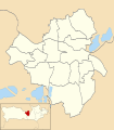 Reading UK ward map 2010 (blank).svg 1,108 × 1,266; 170 KB
 Reading UK ward map 2022 (blank).svg 1,600 × 1,600; 322 KB
 Reading uni whiteknights campus.png 888 × 731; 571 KB
 Route Map of Reading Corporation Tramways.jpg 3,203 × 1,678; 1.4 MB
 Thames valley.png 1,006 × 486; 537 KB


.svg)
.svg)


.svg)
.svg)