Category:Maps of Potries
Jump to navigation
Jump to search
Media in category "Maps of Potries"
The following 11 files are in this category, out of 11 total.
-
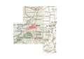
 Karte Gemeinde Potries 2022.png 5,000 × 5,980; 2.61 MB
-
 Localització de Potries respecte de la Safor.png 400 × 400; 52 KB
-
 Localització de Potries respecte del País Valencià.png 238 × 400; 27 KB
-
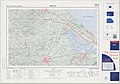
 Mapa de Potries MTN25 2007.pdf 1,752 × 1,239; 1.81 MB
-
 MTN25-0795c2-2007-Real de Gandia.jpg 7,651 × 5,187; 9.88 MB
-
 MTN25-0795c4-2007-Villalonga.jpg 7,637 × 5,189; 9.86 MB
-
 MTN25-0796c1-2007-Gandia.jpg 7,874 × 5,161; 10.21 MB
-
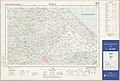 MTN25-0796c3-1988-Oliva.jpg 7,651 × 5,189; 6.52 MB
-
 MTN25-0796c3-1998-Oliva.jpg 7,750 × 5,434; 8.52 MB
-
 MTN25-0796c3-2007-Oliva.jpg 7,874 × 5,160; 12.14 MB
-
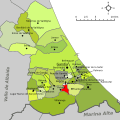 Potríes-Mapa de Safor.svg 396 × 395; 375 KB


