Category:Maps of Naxos
Jump to navigation
Jump to search
Wikimedia category | |||||
| Upload media | |||||
| Instance of | |||||
|---|---|---|---|---|---|
| Category combines topics | |||||
| Naxos Island | |||||
island in the Aegean Sea | |||||
| Instance of | |||||
| Part of | |||||
| Location | Aegean Sea | ||||
| Located in or next to body of water | |||||
| Significant event |
| ||||
| Width |
| ||||
| Length |
| ||||
| Highest point | |||||
| Population |
| ||||
| Area |
| ||||
| Elevation above sea level |
| ||||
| official website | |||||
 | |||||
Media in category "Maps of Naxos"
The following 21 files are in this category, out of 21 total.
-
Series 1404 sheet 342-D Bodrum, published 1960.jpg 6,888 × 5,707; 11.15 MB
-
20221029 Naxos 765.jpg 4,000 × 6,000; 5.39 MB
-
20221029 Naxos 822.jpg 4,000 × 6,000; 5.39 MB
-
20221029 Naxos 823.jpg 6,000 × 4,000; 5.43 MB
-
Geological map of Naxos, description, Geological Museum in Apeiranthos, 190261.jpg 4,788 × 3,591; 9.85 MB
-
Geological map of Naxos, Geological Museum in Apeiranthos, 190260.jpg 4,812 × 3,609; 9.15 MB
-
Gr Cyclades Naxos map.png 540 × 720; 293 KB
-
GR Naxos.PNG 626 × 536; 21 KB
-
GR-Naxos-map.svg 1,536 × 1,735; 603 KB
-
Kastor of Naxos Town, tentative pla, 144158.jpg 4,851 × 3,234; 9.63 MB
-
Kykladen-naxos.png 1,484 × 1,202; 264 KB
-
Map of archaeological sites, Grotta, Chora of Naxos, 190317.jpg 4,369 × 3,277; 8.74 MB
-
Naksos.png 1,000 × 1,108; 186 KB
-
Naxos in Greece.PNG 200 × 204; 18 KB
-
Naxos map.png 238 × 314; 85 KB
-
Naxos Relief Maps for free.jpg 456 × 571; 202 KB
-
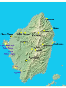
Naxos towns.jpg 255 × 321; 66 KB
-
Naxos, relief.png 313 × 341; 107 KB
-
Nàxos.jpg 1,529 × 1,111; 228 KB
-
Orientation map of Kastro at entrance of Venetian Museum, Naxos, 119989.jpg 3,254 × 2,169; 4.21 MB

