Category:Maps of Liège (city)
Jump to navigation
Jump to search
Wikimedia category | |||||
| Upload media | |||||
| Instance of | |||||
|---|---|---|---|---|---|
| Category combines topics | |||||
| Liège | |||||
city in Wallonia, Belgium | |||||
| Pronunciation audio | |||||
| Instance of |
| ||||
| Location |
| ||||
| Located in or next to body of water | |||||
| Capital | |||||
| Official language |
| ||||
| Head of government |
| ||||
| Legal form |
| ||||
| Inception |
| ||||
| Population |
| ||||
| Area |
| ||||
| Elevation above sea level |
| ||||
| Drainage basin | |||||
| Different from | |||||
| official website | |||||
 | |||||
Subcategories
This category has the following 3 subcategories, out of 3 total.
Media in category "Maps of Liège (city)"
The following 46 files are in this category, out of 46 total.
-
Agglomeration of Liege.png 1,485 × 859; 1.92 MB
-
Agglomération morphologique de Liège.png 3,507 × 2,480; 2.1 MB
-
AgglomérationLiège.png 1,011 × 728; 371 KB
-
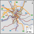
Autoroutes Liège.PNG 1,320 × 940; 905 KB
-
Be-map-fr-liege.png 330 × 355; 30 KB
-
Be-map-liege.png 330 × 355; 26 KB
-
Belgian Railway Line 212.png 1,114 × 818; 531 KB
-
Carte de Liège avec parkings vélos.svg 3,725 × 5,265; 24.86 MB
-
Carte des quartiers de la section d'Angleur.svg 512 × 626; 14 KB
-
Carte des quartiers de la section de Bressoux.svg 512 × 626; 11 KB
-
Carte des quartiers de la section de Grivegnée.svg 512 × 626; 13 KB
-
Carte des quartiers de la section de Liège.svg 512 × 626; 33 KB
-
CentreLiège.png 1,276 × 872; 1.1 MB
-
CentreLiègeQuartiers.png 1,276 × 872; 1.14 MB
-
Complexe résidentiel urbain de Liège en 2017.png 3,507 × 2,480; 815 KB
-
Diocèse Liège 1789.svg 2,000 × 1,922; 801 KB
-
District liège-01.svg 512 × 377; 53 KB
-
Liege Belgium street map.svg 853 × 829; 2.02 MB
-
Liege map.svg 687 × 808; 2.54 MB
-
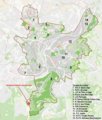
Liege-Main-Football-Stadium.png 1,022 × 1,006; 343 KB
-
Liege.RELSE.TULE.SNCV.png 1,504 × 1,253; 1.96 MB
-
Liège - Section de la ville de Liège.svg 512 × 631; 7 KB
-
Liège - Transport.svg 512 × 504; 61 KB
-
Liège agglomération Liège Belgium Map.PNG 800 × 590; 76 KB
-
Liège Liège Belgium Map.svg 977 × 721; 3.11 MB
-
Liège OSM 01.png 742 × 557; 432 KB
-
Liège OSM 02.png 446 × 588; 386 KB
-
Liège OSM 03.png 446 × 588; 259 KB
-
Liège XIIIes LambertLeBègue.svg 420 × 595; 729 KB
-
Liège.png 800 × 1,066; 115 KB
-
LuikLocatie.png 290 × 220; 5 KB
-
Map of Grand Curtius.png 1,021 × 758; 132 KB
-
Map of Liege.png 923 × 766; 359 KB
-
Map of Val-Benoît.png 717 × 988; 293 KB
-
Pedestrian zone of Liège.png 920 × 856; 897 KB
-
Plan Equerre Expo Inter 1939.jpg 2,701 × 2,631; 861 KB
-
Rue Vaudrée.jpg 1,280 × 616; 350 KB
-
Région urbaine de Liège en 2017.png 800 × 590; 79 KB
-
Sections de la commune de Liège.png 362 × 466; 59 KB
-
Sections de Liège et communes limitrophes.svg 324 × 409; 84 KB
-
Sections de Liège.svg 512 × 633; 20 KB
-
SGIB-Coteaux Citadelle.png 903 × 674; 469 KB
-
Terrains de football à Liège.png 800 × 941; 1,007 KB
-
Tram Liège plan.svg 742 × 550; 274 KB
-
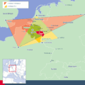
Trianglestrategique etor.gif 900 × 900; 76 KB
-
ZP 5277 - Zone de Police Liège.GIF 888 × 734; 27 KB


