Category:Maps of La Cresse (Aveyron)
Jump to navigation
Jump to search
Media in category "Maps of La Cresse (Aveyron)"
The following 11 files are in this category, out of 11 total.
-
 12086-La Cresse-Arron.png 3,057 × 2,480; 1.23 MB
-
 12086-La Cresse-cadastre.svg 961 × 744; 3.3 MB
-
 12086-La Cresse-Canton.png 3,057 × 2,480; 1.26 MB
-
 12086-La Cresse-EPCI.png 3,057 × 2,480; 1.25 MB
-
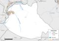 12086-La Cresse-Hydro.png 3,519 × 2,480; 1.12 MB
-
 12086-La Cresse-Natura2000.png 7,039 × 4,960; 2.55 MB
-
 12086-La Cresse-Sols.png 3,507 × 2,480; 1.38 MB
-
 12086-La Cresse-ZNIEFF1.png 3,519 × 2,480; 1.33 MB
-
 12086-La Cresse-ZNIEFF2.png 3,519 × 2,480; 945 KB
-
 12086-La Cresse-Zone inondable.svg 1,070 × 744; 1.85 MB
-
 Map commune FR insee code 12086.png 756 × 605; 64 KB


