Category:Maps of Kotsiubyntsi
Jump to navigation
Jump to search
Васильковецька громада
Населені пункти: Васильківці · Жабинці · Коцюбинці · Крогулець · Нижбірок · Старий Нижбірок · Целіїв · Чабарівка ·
Населені пункти: Васильківці · Жабинці · Коцюбинці · Крогулець · Нижбірок · Старий Нижбірок · Целіїв · Чабарівка ·
Media in category "Maps of Kotsiubyntsi"
The following 3 files are in this category, out of 3 total.
-
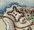 Мапа Фрідріха фон Міґа, Коцюбинський замок.png 299 × 265; 124 KB
-

-
 Села Чортківщини на мапі Гійома де Боплана, XVII ст.png 936 × 256; 423 KB

.png)