Category:Maps of Kleve
Jump to navigation
Jump to search
Wikimedia category | |||||
| Upload media | |||||
| Instance of | |||||
|---|---|---|---|---|---|
| Category combines topics | |||||
| Kleve | |||||
town in Kleve District, in North Rhine-Westphalia, Germany | |||||
| Instance of |
| ||||
| Location |
| ||||
| Applies to jurisdiction | |||||
| Located in or next to body of water | |||||
| Head of government |
| ||||
| Founded by | |||||
| Inception |
| ||||
| Population |
| ||||
| Area |
| ||||
| Elevation above sea level |
| ||||
| Different from | |||||
| official website | |||||
 | |||||
Kreis Kleve  Bedburg-Hau · Emmerich am Rhein · Geldern · Goch · Issum · Kalkar · Kerken · Kevelaer · Kleve · Kranenburg · Rees · Rheurdt · Straelen · Uedem · Wachtendonk · Weeze ·
Media in category "Maps of Kleve"
The following 17 files are in this category, out of 17 total.
-
DB 2516 railway map.png 1,370 × 952; 1.32 MB
-
Haus Riswick PM16-20.jpg 4,896 × 3,672; 4.73 MB
-
Ketelwald-Reichswald.jpg 2,048 × 1,536; 635 KB
-
Ketelwald-topo.gif 883 × 624; 127 KB
-
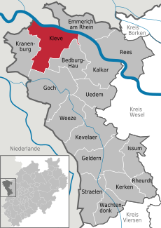
Kleve in KLE.svg 438 × 619; 292 KB
-
Kleve-Kermisdahl 02 PM14.jpg 1,048 × 648; 397 KB
-
Kleve-Reichswalde Infotafel Geschichte PM19-01.jpg 4,851 × 3,575; 5.38 MB
-
Kleve-Rindern Drususdeich Rindernsche Kolke PM20-01.jpg 3,630 × 2,695; 2.45 MB
-
Kleve-Rindern Drususdeich Rindernsche Kolke PM20-05.jpg 4,896 × 3,672; 7.39 MB
-
Kleve-Rindern Drususdeich Rindernsche Kolke PM20-06.jpg 4,896 × 3,672; 7.36 MB
-
Kleve-Rindern Drususdeich Rindernsche Kolke PM20-11.jpg 4,257 × 2,973; 3.68 MB
-
Lage der Stadt Kleve in Deutschland.png 188 × 235; 5 KB
-
Neuer Tiergarten Kleve Infotafel PM16.jpg 4,896 × 3,672; 6.2 MB
-
ReichswaldRijkVanNijmegen.png 3,011 × 2,480; 2.51 MB
-
Schild botanischer Garten.jpg 3,264 × 1,836; 1.09 MB
-
Schild Neuer Garten.jpg 1,836 × 3,264; 1.38 MB
-
Spoorlijn Nijmegen - Kleve.png 1,313 × 922; 1.28 MB


