Category:Maps of Giessenlanden
Jump to navigation
Jump to search
Wikimedia category | |||||
| Upload media | |||||
| Instance of | |||||
|---|---|---|---|---|---|
| Category combines topics | |||||
| Giessenlanden | |||||
former municipality in the Netherlands | |||||
| Pronunciation audio | |||||
| Instance of |
| ||||
| Location |
| ||||
| Located in or next to body of water |
| ||||
| Inception |
| ||||
| Dissolved, abolished or demolished date |
| ||||
| Population |
| ||||
| Replaces |
| ||||
| official website | |||||
 | |||||
Subcategories
This category has the following 7 subcategories, out of 7 total.
M
- Maps of Arkel (3 F)
- Maps of Hoogblokland (2 F)
- Maps of Hoornaar (2 F)
- Maps of Noordeloos (2 F)
- Maps of Schelluinen (2 F)
Media in category "Maps of Giessenlanden"
The following 16 files are in this category, out of 16 total.
-
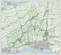
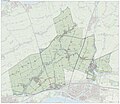
2013-Giessenlanden.jpg 2,435 × 2,188; 3.81 MB
-
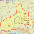
BAG woonplaatsen - Gemeente Giessenlanden.png 2,419 × 2,419; 580 KB
-
Gem-Giessenlanden-2014Q1.jpg 4,908 × 4,320; 11.64 MB
-
Gem-Giessenlanden-OpenTopo.jpg 6,055 × 5,240; 13.52 MB
-
LocatieGiessenlanden.png 280 × 130; 10 KB
-
Map - NL - Giessenlanden (2009).svg 625 × 575; 1.78 MB
-
Map NL - Giessenlanden - Arkel.png 800 × 600; 13 KB
-
Map NL - Giessenlanden - Giessen-Oudekerk.png 800 × 600; 13 KB
-
Map NL - Giessenlanden - Giessenburg.png 800 × 600; 13 KB
-
Map NL - Giessenlanden - Hoogblokland.png 800 × 600; 13 KB
-
Map NL - Giessenlanden - Hoornaar.png 800 × 600; 13 KB
-
Map NL - Giessenlanden - Noordeloos.png 800 × 600; 13 KB
-
Map NL - Giessenlanden - Overslingeland.png 800 × 600; 13 KB
-
Map NL - Giessenlanden - Rietveld.png 800 × 600; 13 KB
-
Map NL - Giessenlanden - Schelluinen.png 800 × 600; 13 KB
-
Netherlands, Peursum, map, around 1865-1870.PNG 2,396 × 2,004; 4.7 MB


