
Category:Maps of Free State municipalities with 2011 borders
This category contains maps of municipalities in the Free State province of South Africa that show the the municipal borders as they were after the municipal election of 18 May 2011. The borders of many municipalities across the country changed again in 2016.
Media in category "Maps of Free State municipalities with 2011 borders"
The following 33 files are in this category, out of 33 total.
-
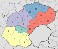
 Map of the Free State with districts labelled (2011).svg 828 × 693; 503 KB
-
 Map of the Free State with municipalities blank (2011).svg 828 × 693; 1.34 MB
-
 Blank map of the Free State (2011).svg 749 × 667; 461 KB
-
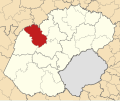
 Map of the Free State with Dihlabeng highlighted (2011).svg 828 × 693; 463 KB
-
 Map of South Africa with Fezile Dabi highlighted (2011).svg 809 × 709; 496 KB
-
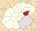
 Map of the Free State with Fezile Dabi highlighted (2011).svg 828 × 693; 481 KB
-
 Map of the Free State with Kopanong highlighted (2011).svg 828 × 693; 469 KB
-
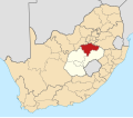
 Map of South Africa with Lejweleputswa highlighted (2011).svg 809 × 709; 496 KB
-
 Map of the Free State with Lejweleputswa highlighted (2011).svg 828 × 693; 483 KB
-
 Map of the Free State with Letsemeng highlighted (2011).svg 828 × 693; 464 KB
-
 Map of the Free State with Mafube highlighted (2011).svg 828 × 693; 461 KB
-
 Map of the Free State with Maluti-a-Phofung highlighted (2011).svg 828 × 693; 461 KB
-
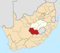
 Map of South Africa with Mangaung highlighted (2011).svg 809 × 709; 489 KB
-
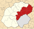
 Map of the Free State with Mangaung highlighted (2011).svg 828 × 693; 464 KB
-
 Map of the Free State with Mantsopa highlighted (2011).svg 828 × 693; 461 KB
-
-
 Map of the Free State with Masilonyana highlighted (2011).svg 828 × 693; 462 KB
-
 Map of the Free State with Matjhabeng highlighted (2011).svg 828 × 693; 460 KB
-
 Map of the Free State with Metsimaholo highlighted (2011).svg 828 × 693; 461 KB
-
 Map of the Free State with Mohokare highlighted (2011).svg 828 × 693; 468 KB
-
 Map of the Free State with Moqhaka highlighted (2011).svg 828 × 693; 468 KB
-
 Map of the Free State with Nala highlighted (2011).svg 828 × 693; 463 KB
-
 Map of the Free State with Naledi highlighted (2011).svg 828 × 693; 460 KB
-
 Map of the Free State with Ngwathe highlighted (2011).svg 828 × 693; 461 KB
-
 Map of the Free State with Nketoana highlighted (2011).svg 828 × 693; 461 KB
-
 Map of the Free State with Phumelela highlighted (2011).svg 828 × 693; 470 KB
-
 Map of the Free State with Setsoto highlighted (2011).svg 828 × 693; 465 KB
-
 Map of South Africa with Thabo Mofutsanyana highlighted (2011).svg 809 × 709; 499 KB
-
 Map of the Free State with Thabo Mofutsanyana highlighted (2011).svg 828 × 693; 492 KB
-
 Map of the Free State with Tokologo highlighted (2011).svg 828 × 693; 463 KB
-
 Map of the Free State with Tswelopele highlighted (2011).svg 828 × 693; 462 KB
-
 Map of South Africa with Xhariep highlighted (2011).svg 809 × 709; 497 KB
-
 Map of the Free State with Xhariep highlighted (2011).svg 828 × 693; 489 KB
.svg)
.svg)
.svg)
.svg)
.svg)
.svg)
.svg)
.svg)
.svg)
.svg)
.svg)
.svg)
.svg)
.svg)
.svg)
.svg)
.svg)
.svg)
.svg)
.svg)
.svg)
.svg)
.svg)
.svg)
.svg)
.svg)
.svg)
.svg)
.svg)
.svg)
.svg)
.svg)
.svg)