Category:Maps of Erie County, Ohio
Jump to navigation
Jump to search
Wikimedia category | |||||
| Upload media | |||||
| Instance of | |||||
|---|---|---|---|---|---|
| Category combines topics | |||||
| Erie County | |||||
county in Ohio, United States | |||||
| Instance of | |||||
| Named after | |||||
| Location | Ohio | ||||
| Capital | |||||
| Headquarters location | |||||
| Inception |
| ||||
| Population |
| ||||
| Area |
| ||||
| Different from | |||||
| official website | |||||
 | |||||
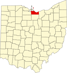
Erie County is in northern Ohio in the United States. Its county seat is Sandusky.
Subcategories
This category has the following 5 subcategories, out of 5 total.
Media in category "Maps of Erie County, Ohio"
The following 30 files are in this category, out of 30 total.
-
Bass Islands map.png 800 × 990; 261 KB
-
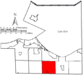
Berlin Erie.PNG 655 × 597; 23 KB
-
Detailed map of Fairview Lanes, Ohio.png 575 × 425; 19 KB
-
Detailed map of Sandusky South, Ohio.png 575 × 425; 50 KB
-
Florence Erie.PNG 655 × 597; 23 KB
-
Groton Erie.PNG 655 × 597; 23 KB
-
Huron Erie.PNG 655 × 597; 24 KB
-
Map of Ohio highlighting Erie County.svg 1,050 × 1,141; 37 KB
-
Map showing Plum Brook's location relative to Lake Erie and other cities. (9465033629).jpg 2,400 × 3,000; 2.38 MB
-
Margaretta Erie.PNG 655 × 597; 24 KB
-
Milan Erie.PNG 655 × 597; 24 KB
-
OHMap-doton-Avery.png 309 × 352; 17 KB
-
OHMap-doton-Bay View.png 274 × 300; 10 KB
-
OHMap-doton-Bellevue.png 274 × 300; 10 KB
-
OHMap-doton-Berlin Heights.png 274 × 300; 10 KB
-
OHMap-doton-Beulah-Beach.png 309 × 352; 17 KB
-
OHMap-doton-Birmingham.png 309 × 352; 17 KB
-
OHMap-doton-Bloomingville.png 309 × 352; 17 KB
-
OHMap-doton-Fairview Lanes.png 274 × 300; 10 KB
-
OHMap-doton-Huron.png 274 × 300; 10 KB
-
OHMap-doton-Kelleys Island.png 274 × 300; 10 KB
-
OHMap-doton-Milan.png 274 × 300; 10 KB
-
OHMap-doton-Sandusky South.png 274 × 300; 10 KB
-
OHMap-doton-Vermilion.png 274 × 300; 10 KB
-
Oxford Erie.PNG 655 × 597; 24 KB
-
Perkins Erie.PNG 655 × 597; 24 KB
-
Sandusky Bay.PNG 342 × 174; 12 KB
-
Vermilion Erie.PNG 655 × 597; 24 KB


