Category:Maps of East Baton Rouge Parish, Louisiana
Jump to navigation
Jump to search
Parishes of Louisiana: Acadia · Allen · Ascension · Assumption · Avoyelles · Beauregard · Bienville · Bossier · Caddo · Calcasieu · Caldwell · Cameron · Catahoula · Claiborne · Concordia · DeSoto · East Baton Rouge · East Carroll · East Feliciana · Evangeline · Franklin · Grant · Iberia · Iberville · Jackson · Jefferson · Jefferson Davis · Lafayette · Lafourche · LaSalle · Lincoln · Livingston · Madison · Morehouse · Natchitoches · Orleans · Ouachita · Plaquemines · Pointe Coupee · Rapides · Red River · Richland · Sabine · Saint Bernard · Saint Charles · Saint Helena · Saint James · Saint John the Baptist · Saint Landry · Saint Martin · Saint Mary · Saint Tammany · Tangipahoa · Tensas · Terrebonne · Union · Vermilion · Vernon · Washington · Webster · West Baton Rouge · West Carroll · West Feliciana · Winn
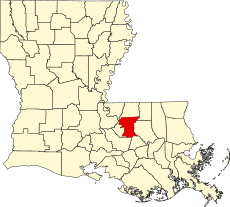
English: East Baton Rouge Parish is located in Louisiana in the United States. Its parish seat is Baton Rouge.
Wikimedia category | |||||
| Upload media | |||||
| Instance of | |||||
|---|---|---|---|---|---|
| Category combines topics | |||||
| East Baton Rouge Parish | |||||
parish in Louisiana, United States | |||||
| Instance of | |||||
| Location | Louisiana | ||||
| School district |
| ||||
| Capital | |||||
| Headquarters location | |||||
| Inception |
| ||||
| Significant event | |||||
| Population |
| ||||
| Area |
| ||||
| official website | |||||
 | |||||
Media in category "Maps of East Baton Rouge Parish, Louisiana"
The following 56 files are in this category, out of 56 total.
-
Baton Rouge-Pierre Part CSA.png 542 × 490; 36 KB
-
Baton Rouge–Hammond combined statistical area.svg 5,018 × 4,515; 550 KB
-
East Baton Rouge Parish District Map.png 532 × 531; 48 KB
-
East Baton Rouge Parish Louisiana incorporated and unincorporated areas.svg 1,023 × 741; 8.08 MB
-
East Baton Rouge Parish Louisiana.png 300 × 275; 13 KB
-
LAMap-doton-Brownfields.png 300 × 275; 12 KB
-
LAMap-doton-Gardere.png 300 × 275; 12 KB
-
LAMap-doton-Inniswold.png 300 × 275; 12 KB
-
LAMap-doton-Merrydale.png 300 × 275; 12 KB
-
LAMap-doton-Monticello.png 300 × 275; 12 KB
-
LAMap-doton-Oak Hills Place.png 300 × 275; 12 KB
-
LAMap-doton-Shenandoah.png 300 × 275; 12 KB
-
LAMap-doton-Village St. George.png 300 × 275; 12 KB
-
LAMap-doton-Westminster.png 300 × 275; 12 KB
-
Louisiana Senate District 13 (2010).png 3,165 × 2,781; 990 KB
-
Louisiana Senate District 14 (2010).png 3,165 × 2,781; 988 KB
-
Louisiana Senate District 15 (2010).png 3,165 × 2,781; 988 KB
-
Louisiana Senate District 16 (2010).png 3,165 × 2,781; 987 KB
-
Louisiana Senate District 17 (2010).png 3,165 × 2,781; 1,004 KB
-
Louisiana Senate District 6 (2010).png 3,165 × 2,781; 995 KB
-
Map of East Baton Rouge Parish Louisiana With Municipal and District Labels.PNG 1,266 × 1,265; 154 KB
-
Map of East Baton Rouge Parish Louisiana With Municipal Labels.PNG 1,266 × 1,265; 134 KB
-
Map of Louisiana highlighting East Baton Rouge Parish.svg 1,255 × 1,129; 169 KB
-
Plantations and river landings of Baton Rouge Parishes of Louisiana circa 1884.jpg 2,262 × 5,020; 1.29 MB
-
Port Hudson and Vicinity 1864.png 2,226 × 3,039; 12.35 MB
-
Port Hudson Plains Store Four.svg 1,538 × 1,013; 33 KB
-
Seige of Port Hudson.jpg 1,769 × 2,170; 764 KB


