Category:Maps of Darwin, Northern Territory
Jump to navigation
Jump to search
Subcategories
This category has the following 2 subcategories, out of 2 total.
L
Media in category "Maps of Darwin, Northern Territory"
The following 19 files are in this category, out of 19 total.
-
-
 Admiralty Chart No 925 Approaches to Port Darwin, Published 1943.jpg 11,060 × 16,298; 23.65 MB
-
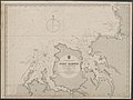
 Admiralty Chart No 925 Australia - North coast, Port Darwin, Published 1886.jpg 8,160 × 11,996; 33.31 MB
-
 Admiralty Chart No 925 Australia - North coast, Port Darwin, Published 1929 nla.obj-232244253.jpg 8,174 × 11,913; 36.74 MB
-
 Admiralty Chart No 925 Port Darwin, Published 1929.jpg 11,073 × 16,168; 46.25 MB
-
 Cox Peninsula Road 0216.svg 478 × 478; 94 KB
-
 Darwin locator-MJC.png 563 × 476; 12 KB
-
 Darwin's Context (6525061557).jpg 887 × 720; 169 KB
-
 Darwin, Australie.png 452 × 599; 108 KB
-
 Darwin-Palmerston locator map.svg 1,293 × 770; 5.92 MB
-
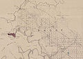 Hundred of Bagot 1872.jpg 1,200 × 848; 213 KB
-
 Locations of Darwin's two railway stations.tif 1,559 × 1,048; 6.24 MB
-
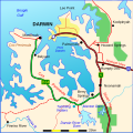
 Map of the Adelaide–Darwin rail route and the former Central Australia Railway.png 2,338 × 1,653; 1.25 MB
-
 Map of the Wards and Suburbs of Darwin, Northern Territory.png 3,060 × 3,375; 1.71 MB
-
 Map of the Wards and Suburbs of Darwin, Northern Territory.svg 1,469 × 1,620; 1.54 MB
-
 Metro NT.png 1,159 × 758; 89 KB
-
 NTerrMap-doton-Darwin.png 146 × 205; 2 KB
-
 Palmerston County 1886.jpg 1,007 × 1,005; 204 KB
-


.jpg)


