Category:Maps of Cheshire
Jump to navigation
Jump to search
Wikimedia category | |||||
| Upload media | |||||
| Instance of | |||||
|---|---|---|---|---|---|
| Category combines topics | |||||
| Cheshire | |||||
ceremonial county in England, United Kingdom      | |||||
| Instance of | |||||
| Location |
| ||||
| Capital | |||||
| Population |
| ||||
| Area |
| ||||
| Different from | |||||
| Said to be the same as | Cheshire (historic county of England, ceremonial county of England, 1844) | ||||
 | |||||
Subcategories
This category has the following 10 subcategories, out of 10 total.
!
C
- Cheshire RJD 1914 (17 F)
E
- Election maps of Cheshire (86 F)
H
- Hundreds of Cheshire (12 F)
M
O
R
- Rail transport maps of Cheshire (20 F)
Media in category "Maps of Cheshire"
The following 55 files are in this category, out of 55 total.
-
 Bickerton Hill map.png 660 × 613; 155 KB
-
 British Rail Borderlands Line diagram with interconnections.svg 1,576 × 1,576; 4 KB
-
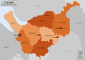
 Castles in Cheshire.png 722 × 552; 429 KB
-
 Cheshire - British Isles.svg 1,260 × 1,835; 943 KB
-
 Cheshire Brit Isles Sect 3.svg 939 × 677; 940 KB
-
 Cheshire Brit Isles Sect 5.svg 809 × 743; 939 KB
-
 Cheshire Brit Isles Sect 6.svg 545 × 593; 938 KB
-
 Cheshire Ceremonial Numbered.png 200 × 159; 4 KB
-
 Cheshire domesday hundreds.svg 933 × 900; 470 KB
-
 Cheshire map.png 1,076 × 938; 23 KB
-
 Cheshire Natural Areas.jpg 516 × 394; 78 KB
-
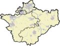 Cheshire outline map (2009).png 710 × 545; 371 KB
-
 Cheshire outline map with UK (2009).png 722 × 552; 396 KB
-
 Cheshire outline map with UK.png 722 × 552; 412 KB
-
 Cheshire outline.png 500 × 394; 26 KB
-
 Cheshire UK constituency map (blank).svg 1,425 × 1,098; 1.14 MB
-
 Cheshire UK district map (blank).svg 1,425 × 1,098; 999 KB
-
 Cheshire UK location map.svg 1,425 × 1,098; 2.23 MB
-
 Cheshire UK locator map 2010.svg 1,108 × 1,345; 302 KB
-
 Cheshire UK parish map (blank).svg 1,425 × 1,098; 2.63 MB
-
 Cheshire UK PCC election 2024.svg 1,425 × 1,098; 1,000 KB
-
 Cheshire UK relief location map.jpg 1,999 × 1,539; 292 KB
-
 Cheshire UK ward map (blank).svg 1,425 × 1,098; 1.64 MB
-
 Cheshire unitary labell.png 500 × 394; 34 KB
-
 Cheshire unitary number.png 500 × 394; 29 KB
-
 Cheshire unitary.png 500 × 394; 28 KB
-
 Cheshire-Domesday-Hundreds.svg 933 × 900; 476 KB
-
 Cheshire-Later-Hundreds.svg 1,166 × 1,166; 115 KB
-
 Cheshire1832Map.png 2,000 × 1,412; 309 KB
-
 CheshireBrit3.PNG 698 × 491; 28 KB
-
 CheshireBrit5.PNG 625 × 569; 26 KB
-
 CheshireNumbered.png 200 × 129; 12 KB
-
 Chesterdeaneries1835.png 936 × 823; 269 KB
-
 Chesterdeaneries1835.svg 1,170 × 1,029; 692 KB
-
 ChesterDiocese-1541.png 599 × 812; 88 KB
-
 ChesterDiocese-1541.svg 749 × 1,015; 167 KB
-
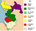 ChesterDioceseChanges-19th.svg 1,343 × 1,164; 103 KB
-
 England Police Forces (Cheshire).svg 1,108 × 1,345; 312 KB
-
 EnglandPoliceCheshire.png 2,165 × 2,670; 87 KB
-
 Cheshire Hundreds.svg 1,000 × 716; 578 KB
-
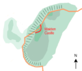 Maiden Castle (Cheshire) map.png 522 × 449; 134 KB
-
 Manchester City Region.png 2,766 × 2,053; 423 KB
-
 Manchester Ship Canal Landsat.jpg 605 × 441; 462 KB
-
 Manchester Ship Canal map.svg 3,119 × 1,483; 47 KB
-
 Manchester Transport Museum SELNEC Futuroute sign.jpg 2,048 × 1,536; 910 KB
-
 Map showing the traditional, geographical county of Cheshire, England,.png 4,967 × 4,967; 4.34 MB
-
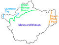
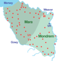 Mara and Mondrem.png 800 × 804; 100 KB
-
 New Cheshire Ceremonial Numbered.png 200 × 159; 3 KB
-
 Norton Priory plan.png 1,689 × 1,000; 119 KB
-
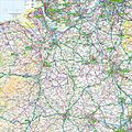 Ordnance Survey 1-250000 - SJ.jpg 4,000 × 4,000; 9.38 MB
-
 River Bollin catchment area.png 957 × 809; 97 KB
-
 River Dean catchment area.png 771 × 643; 37 KB
-
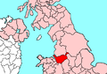
 Uk-cheshire.png 145 × 173; 6 KB
-
 Warrington UK ward map 2024.svg 1,291 × 1,306; 467 KB
-
 Wrenbury map.jpg 275 × 242; 33 KB


.png)
.png)


.svg)


_map.png)


.svg)
.svg)
.svg)
.svg)