Category:Maps of Chernivtsi Oblast
Jump to navigation
Jump to search
Regions of Ukraine:
Oblasts: Cherkasy · Chernihiv · Chernivtsi · Dnipropetrovsk · Donetsk · Ivano-Frankivsk · Kharkiv · Kherson · Khmelnytskyi · Kyiv · Kirovohrad · Luhansk · Lviv · Mykolaiv · Odesa · Poltava · Rivne · Sumy · Ternopil · Vinnytsia · Volyn · Zakarpattia · Zaporizhzhia · Zhytomyr – Cities: Kyiv · Sevastopol – Autonomous Republic: Crimea
Oblasts: Cherkasy · Chernihiv · Chernivtsi · Dnipropetrovsk · Donetsk · Ivano-Frankivsk · Kharkiv · Kherson · Khmelnytskyi · Kyiv · Kirovohrad · Luhansk · Lviv · Mykolaiv · Odesa · Poltava · Rivne · Sumy · Ternopil · Vinnytsia · Volyn · Zakarpattia · Zaporizhzhia · Zhytomyr – Cities: Kyiv · Sevastopol – Autonomous Republic: Crimea
Wikimedia category | |||||
| Upload media | |||||
| Instance of | |||||
|---|---|---|---|---|---|
| Category combines topics | |||||
| Chernivtsi Oblast | |||||
oblast of Ukraine   .svg)  | |||||
| Instance of | |||||
| Location |
| ||||
| Capital | |||||
| Legislative body |
| ||||
| Official language | |||||
| Head of government | |||||
| Inception |
| ||||
| Population |
| ||||
| Area |
| ||||
| official website | |||||
 | |||||
Subcategories
This category has the following 11 subcategories, out of 11 total.
B
- Maps of Borivtsi (1 F)
D
- Maps of Doroshivtsi (1 F)
K
- Maps of Kyseliv (1 F)
L
M
- Maps of Maliatyntsi (1 F)
P
- Maps of Pryhorodok (1 F)
V
Y
- Maps of Yuzhynets (1 F)
Media in category "Maps of Chernivtsi Oblast"
The following 53 files are in this category, out of 53 total.
-
 Cernovicka oblast narodnosti.png 946 × 544; 43 KB
-
 Chernivci regions.svg 1,169 × 436; 304 KB
-
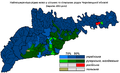
 Chernivetska2001ethnic.PNG 871 × 533; 46 KB
-
 Chernivetska2001languages.PNG 706 × 413; 123 KB
-
 Chernivetska2001languages2.PNG 871 × 533; 49 KB
-
 Chernivetska2001polish.PNG 871 × 533; 42 KB
-
 Chernivetska2001russian.PNG 871 × 545; 52 KB
-
 Chernivtsi in Ukraine.svg 1,547 × 1,041; 1.27 MB
-
 Chernivtsi Oblast 2020 subdivisions.jpg 1,410 × 997; 103 KB
-
 Chernivtsi oblast detail map.png 469 × 240; 15 KB
-
 Chernivtsi Oblast in Ukraine (de jure).svg 1,547 × 1,041; 716 KB
-
 Chernivtsi Ukraine.png 8,000 × 4,500; 2.04 MB
-
 Chernovickiy rayon 2020.jpg 668 × 423; 40 KB
-
 Chernovickiy rayon 2020.svg 533 × 337; 156 KB
-
 Declared Romanians and Moldovans in Chernivtsi Oblast.PNG 800 × 387; 134 KB
-
 Dnestrovskiy rayon 2020.jpg 668 × 423; 39 KB
-
 Dnestrovskiy rayon 2020.svg 533 × 337; 157 KB
-
 Ethnic map of Chernivtsi region 1980.png 596 × 289; 19 KB
-
 Hertsa Raion.svg 781 × 842; 1.1 MB
-
 Hlyboka Raion.svg 821 × 745; 1.59 MB
-
 Kelmentsi Raion.svg 909 × 861; 607 KB
-
 Khotin Uprising on January 19, 1919.svg 756 × 553; 488 KB
-
 Khotyn Raion.svg 862 × 747; 946 KB
-
 Kitsman Raion.svg 736 × 1,016; 3.45 MB
-
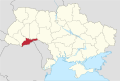
 Locator map of Chernivtsi province.svg 887 × 589; 542 KB
-
 Map of Ukraine political Karpatskyi raion.png 800 × 559; 161 KB
-
 Map of Ukraine political simple Oblast Czernowitz.png 2,466 × 1,749; 203 KB
-

-
 Novoselytsia Raion.svg 1,011 × 540; 1.2 MB
-
 Putyla Raion.svg 553 × 1,017; 1.59 MB
-
 Raions of Chernivtsi Oblast (named map).png 1,153 × 558; 42 KB
-
 Romanianlang2001chernivtsi.PNG 871 × 533; 55 KB
-
 Shypyntsi-Map.JPG 800 × 533; 48 KB
-
 Sokyriany Raion.svg 1,118 × 876; 352 KB
-
 Storozhynets Raion.svg 812 × 753; 3.49 MB
-
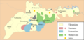
 Tchernivtsi oblast 2001.png 871 × 533; 36 KB
-
 Tschernowitz historical.PNG 500 × 241; 72 KB
-
 Tschernowitz historisch.PNG 500 × 241; 78 KB
-
 Ukraine Chernihiv small.png 213 × 110; 14 KB
-
 Ukrainianlang2001chernivtsi.PNG 871 × 535; 43 KB
-
 UPA-structure.PNG 780 × 570; 498 KB
-
 USSR map NM 35-10 -verso- Chernovtsy and Vicinity.jpg 2,449 × 2,804; 1.44 MB
-
 Vizhnickiy rayon 2020.jpg 668 × 423; 39 KB
-
 Vizhnickiy rayon 2020.svg 533 × 337; 151 KB
-
 Vyzhnytsia Raion.svg 600 × 1,022; 2.01 MB
-
 Zastavna Raion.svg 864 × 745; 1.81 MB
-
 Волоківська ОТГ.png 424 × 316; 158 KB
-
 Зелений Гай карта 1773.jpg 2,096 × 1,160; 2.21 MB
-
 Зелений Гай карта 1775.jpg 1,608 × 1,008; 1.37 MB
-
 Перспективний план формування громад Чернівецької області (КМУ).jpg 1,494 × 820; 430 KB
-
 Схема руху учасників Буковинського віче.jpg 1,939 × 1,881; 349 KB
-
 Украинские Карпаты.png 1,500 × 1,275; 1.21 MB
-
 Черновицкая область 2.png 615 × 342; 22 KB


.svg)


.png)


.jpg)


