Category:Maps of Brest, France
Jump to navigation
Jump to search
Wikimedia category | |||||
| Upload media | |||||
| Instance of | |||||
|---|---|---|---|---|---|
| Category combines topics | |||||
| Brest | |||||
port city in the Finistère department, Brittany, France   .svg)  | |||||
| Pronunciation audio | |||||
| Instance of | |||||
| Location |
| ||||
| Located in or next to body of water | |||||
| Head of government |
| ||||
| Population |
| ||||
| Area |
| ||||
| Elevation above sea level |
| ||||
| Different from | |||||
| official website | |||||
 | |||||
Subcategories
This category has the following 11 subcategories, out of 11 total.
Media in category "Maps of Brest, France"
The following 18 files are in this category, out of 18 total.
-
 29019-Brest-Sols.png 3,270 × 2,598; 6.45 MB
-
 Brest dot.png 1,804 × 1,689; 164 KB
-
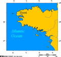 Brittany - France.png 514 × 480; 11 KB
-
 Fortezze a protezione di Brest.jpg 982 × 624; 67 KB
-
 Jardin de Kerbonne 06.jpg 3,458 × 2,305; 3.24 MB
-
 Jardin de Kerbonne 07.jpg 2,371 × 3,557; 2.28 MB
-
 Kanal La Manche s popisem.jpg 3,328 × 1,728; 1.3 MB
-
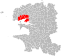 Localisation Brest Métropole dans le Finistère, France.svg 768 × 696; 411 KB
-
 Map commune FR insee code 29019.png 756 × 605; 127 KB
-
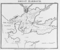 NH 75692 Brest Harbor, France.tif 5,462 × 4,556; 23.74 MB
-
 OpenCycleMap DeltaMapExample.png 240 × 320; 60 KB
-
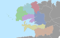 PaysdeBrest.svg 1,442 × 931; 9.05 MB
-
 Plan du stangalar.jpg 1,200 × 1,600; 358 KB
-
 PlanMathon.jpg 464 × 633; 280 KB
-
 RP-P-1956-155 Carte de la rade et des environs de Brest.jpg 4,134 × 5,472; 2.69 MB
-
 Soiaghey Brest, yn Rank.png 564 × 573; 98 KB
-
 Topographie de brest.jpg 1,280 × 1,280; 219 KB
-
 Université de Bretagne Occidentale Map.png 2,035 × 1,209; 653 KB


