Category:Maps of Attica, Ohio
Jump to navigation
Jump to search
Media in category "Maps of Attica, Ohio"
The following 11 files are in this category, out of 11 total.
-
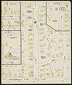
 Attica, Seneca County, Ohio 1897 - DPLA - 61c36ead59edc87fd798671c3a2522d1.jpeg 6,594 × 7,779; 9.08 MB
-
 Attica, Seneca County, Ohio 1904 - DPLA - 96781016f7bc0668b7cb235a09c386e8 (page 2).jpeg 6,601 × 7,817; 8.05 MB
-
 Attica, Seneca County, Ohio 1912 - DPLA - 7698515e10d935403f63ab0d9f537b30 (page 2).jpeg 6,582 × 7,798; 8.35 MB
-
 Attica, Seneca County, Ohio 1922 - DPLA - 4490d495c1ad35c3e3276902b1b9f19f (page 2).jpeg 6,696 × 7,874; 9.3 MB
-
 Attica, Seneca County, Ohio 1922 - DPLA - 4490d495c1ad35c3e3276902b1b9f19f (page 3).jpeg 6,696 × 7,874; 9.76 MB
-
 Attica, Seneca County, Ohio 1922 - DPLA - 4490d495c1ad35c3e3276902b1b9f19f (page 4).jpeg 6,715 × 7,893; 9.34 MB
-
 Attica, Seneca County, Ohio, 1938 - DPLA - 287ddbe5c3a668c170bb4fda2ce3199d (page 2).jpeg 6,696 × 7,874; 7.56 MB
-

-
 Attica, Seneca County, Ohio, 1938 - DPLA - 287ddbe5c3a668c170bb4fda2ce3199d (page 4).jpeg 6,696 × 7,893; 7.57 MB
-
 Map of Seneca County Ohio Highlighting Attica Village.png 677 × 439; 19 KB
-
 OHMap-doton-Attica.png 274 × 300; 10 KB

.jpeg)
.jpeg)
.jpeg)
.jpeg)
.jpeg)
.jpeg)
.jpeg)
.jpeg)

