Category:Maperton
Jump to navigation
Jump to search
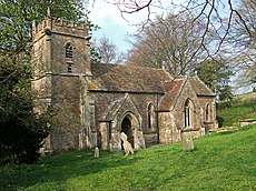
English: Maperton is a village and civil parish in Somerset, England, situated south west of Wincanton in the South Somerset district. The village has a population of 150. However this number includes Elliscombe House care home which alone has an average of 40 residents.
Elliscombe House was closed in 2016. It is expected to reopen in 2021.
village and civil parish in Somerset, UK | |||||
| Upload media | |||||
| Instance of | |||||
|---|---|---|---|---|---|
| Location | South Somerset, Somerset, South West England, England | ||||
| Population |
| ||||
 | |||||
Media in category "Maperton"
The following 40 files are in this category, out of 40 total.
-
A303 - geograph.org.uk - 3024509.jpg 640 × 430; 42 KB
-
A303 - geograph.org.uk - 5301393.jpg 640 × 452; 55 KB
-
A303 - geograph.org.uk - 5301394.jpg 640 × 426; 71 KB
-
A303 at Dancing Cross - geograph.org.uk - 3545993.jpg 1,024 × 768; 115 KB
-
A303 at Dancing Cross - geograph.org.uk - 4745614.jpg 640 × 351; 24 KB
-
A303 at Maperton Ridge - geograph.org.uk - 3024511.jpg 640 × 373; 35 KB
-
A303 at Maperton Ridge - geograph.org.uk - 4057183.jpg 640 × 342; 79 KB
-
A303 east towards Wincanton - geograph.org.uk - 3770734.jpg 2,022 × 1,299; 1.2 MB
-
A303 eastbound in the valley of Witherleigh Farm - geograph.org.uk - 4115840.jpg 1,600 × 1,066; 1.14 MB
-
A303 heading west - geograph.org.uk - 6260727.jpg 1,024 × 684; 183 KB
-
A303 heading west - geograph.org.uk - 6260748.jpg 1,024 × 684; 168 KB
-
A303 heading west - geograph.org.uk - 6260761.jpg 1,024 × 684; 226 KB
-
A303 north of Witherleigh Farm - geograph.org.uk - 3845035.jpg 3,648 × 2,736; 1.34 MB
-
Church of St Peter ^ St Paul - Maperton - geograph.org.uk - 6788384.jpg 1,024 × 768; 244 KB
-
Coloured bales near Maperton Dairy - geograph.org.uk - 5407337.jpg 640 × 427; 89 KB
-
Cottage on the road to Maperton - geograph.org.uk - 6788120.jpg 1,024 × 768; 235 KB
-
Cottages at Dancing Cross - geograph.org.uk - 6789593.jpg 1,024 × 807; 193 KB
-
Farm buildings, south of Maperton - geograph.org.uk - 6788116.jpg 1,024 × 764; 192 KB
-
Field and houses near Maperton - geograph.org.uk - 5407344.jpg 640 × 427; 104 KB
-
Former walled garden, below Stand Hill - geograph.org.uk - 6788098.jpg 1,024 × 778; 214 KB
-
Gate and walls at Maperton House - geograph.org.uk - 5407332.jpg 640 × 427; 104 KB
-
Green fields near Maperton - geograph.org.uk - 5407339.jpg 640 × 427; 107 KB
-
Main gate, Maperton House - geograph.org.uk - 6788368.jpg 1,024 × 768; 239 KB
-
Maperton , A303 - geograph.org.uk - 6620937.jpg 3,677 × 2,758; 2.79 MB
-
Maperton , A303 - geograph.org.uk - 6623849.jpg 4,608 × 3,456; 6.29 MB
-
Maperton church.jpg 640 × 480; 165 KB
-
Maperton House - geograph.org.uk - 6788356.jpg 1,024 × 804; 350 KB
-
Minor road parallel to A303 - geograph.org.uk - 560842.jpg 640 × 425; 83 KB
-
Minor road to North Cheriton - geograph.org.uk - 6788423.jpg 1,024 × 768; 215 KB
-
Path to North Cheriton - geograph.org.uk - 6788105.jpg 1,024 × 768; 216 KB
-
Pedestrian gateway at Maperton House - geograph.org.uk - 6788404.jpg 1,024 × 798; 220 KB
-
South Somerset , The A303 - geograph.org.uk - 3104449.jpg 4,288 × 2,848; 4.74 MB
-
The church of St Peter and St Paul, Maperton - geograph.org.uk - 3373833.jpg 4,000 × 3,000; 4.3 MB
-
The Stable Block of Maperton House - geograph.org.uk - 398435.jpg 640 × 480; 170 KB
-
Turning for North Cheriton - geograph.org.uk - 6788379.jpg 1,024 × 768; 321 KB
-
Quarry Plantation - geograph.org.uk - 560847.jpg 640 × 425; 73 KB
-
Walled Garden In Field Near Maperton - geograph.org.uk - 306420.jpg 640 × 480; 76 KB


