Category:Map of Paris by Jouvin de Rochefort (Boutier 116)
Jump to navigation
Jump to search
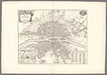
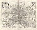
English: There are several editions of this map, dating from [1676] to [after 1679]. It was published by Nicolas de Fer.
- Boutier, Jean (2007). Les Plans de Paris des origines (1493) à la fin de XVIIIe siècle, second edition. Paris: Bibliothèque nationale de France. ISBN 9782717723892.
Media in category "Map of Paris by Jouvin de Rochefort (Boutier 116)"
The following 8 files are in this category, out of 8 total.
-
 1676 Plan de Nicolas de Fer d'après Jouvin.jpg 4,657 × 3,613; 4.98 MB
-
 Albert Jouvin de Rochefort, Paris et ses environs, 1676 - Gallica.jpg 9,179 × 6,951; 14.76 MB
-
 Atlas des anciens plans de Paris - 075. Paris en 1676 - David Rumsey.jpg 25,064 × 17,536; 106.69 MB
-
 Atlas des anciens plans de Paris - Paris en 1676 - BHVP.jpg 4,427 × 3,527; 4.44 MB
-
 Atlas des anciens plans de Paris - Paris en 1676 - David Rumsey.jpg 16,900 × 13,600; 128.2 MB
-
 Paris en 1676, Fac-similé du second Plan de Jouvin de Rochefort - Paris Musées.jpg 12,408 × 8,688; 72.05 MB
-
 Paris en 1676, Fac-similé du second plan de Jouvin de Rochefort - Paris Musées.jpg 12,520 × 8,800; 73.71 MB
-
 Paris et ses environs.jpg 16,941 × 13,306; 69.67 MB


