Category:Manjampatti Valley
Jump to navigation
Jump to search
English: Manjampatti Valley is a 110.9 km² (42.8 sq mi) protected area in the eastern end of Indira Gandhi Wildlife Sanctuary and National Park (IGWS&NP) in Coimbatore district, Tamil Nadu, South India. It is a pristine drainage basin of shola and montane rain forest with high biodiversity, recently threatened by illegal land clearing and cultivation.
10°18′29.88″N 77°16′59.88″E / 10.3083°N 77.2833°E
| Upload media | |||||
| Instance of | |||||
|---|---|---|---|---|---|
| Location |
| ||||
 | |||||
Media in category "Manjampatti Valley"
The following 21 files are in this category, out of 21 total.
-
 3 Statues at Talinji.JPG 3,072 × 2,304; 3.11 MB
-
 Ananthoni Falls.JPG 2,304 × 3,072; 2.53 MB
-
 Ancient Ganesha statue at Thalinji.JPG 2,304 × 3,072; 3.53 MB
-
 Forest Department Anti-Poaching Camp.JPG 3,072 × 2,304; 3.13 MB
-
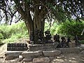 Hindu statues at talinji.JPG 3,072 × 2,304; 3.08 MB
-
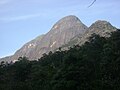 Jambu Malai 2.JPG 3,072 × 2,304; 2.83 MB
-
 Jambu Malai.JPG 2,995 × 2,246; 1.78 MB
-
 Manjampatti bounds.JPG 3,072 × 2,304; 1.62 MB
-
 Manjampatti village.JPG 3,072 × 2,304; 2.96 MB
-
 Manjampatti Watchtower.jpg 3,072 × 2,304; 934 KB
-
 Map-K-Manjampatti Valley-T.jpg 300 × 289; 97 KB
-
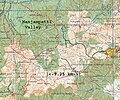 Map-K-Manjampatti Valley-Zout.jpg 888 × 743; 721 KB
-
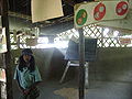 Mungilpallam School.JPG 3,072 × 2,304; 2.99 MB
-
 Mungilpallam village.JPG 3,072 × 2,304; 2.9 MB
-
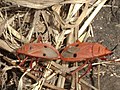 Red beetles.JPG 1,438 × 1,077; 740 KB
-
 SH 17 at Manjampatti Valley.jpg 3,072 × 2,304; 861 KB
-
 Talinji temple ruins 2.JPG 3,072 × 2,304; 2.91 MB
-
 Talinji temple ruins 3.JPG 3,072 × 2,304; 2.96 MB
-
 Talinji Temple ruins.JPG 3,072 × 2,304; 3.1 MB
-
 Talinji Vilage & Vellari Mali Peak.JPG 3,072 × 2,304; 3.09 MB
-
 Talinji village houses.JPG 3,072 × 2,304; 2.96 MB


