Category:Locator maps of territories of the Holy Roman Empire (1648)
Jump to navigation
Jump to search
Media in category "Locator maps of territories of the Holy Roman Empire (1648)"
The following 25 files are in this category, out of 25 total.
-
 Archbishopric of Cologne Locator Map 1.svg 2,320 × 3,300; 141 KB
-
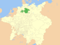 Brunswick-Lüneburg Locator 1648.png 1,972 × 1,494; 1.08 MB
-
 Electorate of Cologne Locator Map 1.svg 2,373 × 3,353; 195 KB
-
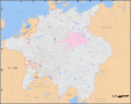 Electorate of Saxony within the Holy Roman Empire 1648.svg 2,283 × 1,810; 2.12 MB
-
 Holy Roman Empire 1648 Ecclesiastical.png 681 × 613; 226 KB
-
 Holy Roman Empire 1648 Hohenzollern Brandenburg.png 681 × 595; 162 KB
-
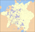
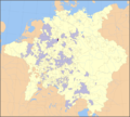
 Holy Roman Empire 1648 Imperial cities.png 681 × 595; 192 KB
-
 HRR 1648 Bayern.png 1,973 × 1,513; 648 KB
-
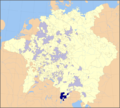
 HRR 1648 Berchtesgaden.png 681 × 613; 226 KB
-
 HRR 1648 Brixen.png 681 × 613; 225 KB
-
 HRR 1648 Cammin.png 1,973 × 1,513; 528 KB
-
 HRR 1648 Corvey.png 681 × 613; 226 KB
-
 HRR 1648 Ellwangen.png 681 × 613; 226 KB
-
 HRR 1648 Erz Bremen.png 1,973 × 1,513; 528 KB
-
 HRR 1648 Freising.png 681 × 613; 225 KB
-
 HRR 1648 Fulda.png 681 × 613; 225 KB
-
 HRR 1648 Glatz.PNG 1,973 × 1,513; 529 KB
-
 HRR 1648 Hst Augsburg.png 681 × 613; 225 KB
-
 HRR 1648 Hst Konstanz.png 681 × 613; 226 KB
-
 HRR 1648 Salem.png 681 × 613; 226 KB
-
 HRR 1648 Salzburg.png 681 × 613; 225 KB
-
 HRR 1648 Tirol.png 1,973 × 1,513; 521 KB
-
 HRR 1648 Trient.png 681 × 613; 225 KB
-
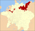
 Nuremberg within the Empire 1648.svg 2,283 × 1,810; 3.85 MB
-
 Territori imperiali (città imperiali) nel 1648.png 1,056 × 923; 753 KB


_nel_1648.png)