Category:Locator maps of settlements in Bogovinje Municipality
Jump to navigation
Jump to search
Media in category "Locator maps of settlements in Bogovinje Municipality"
The following 16 files are in this category, out of 16 total.
-
 Јеловјане во Општина Боговиње.svg 1,488 × 1,100; 824 KB
-
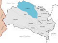
 Боговиње во Општина Боговиње.svg 1,488 × 1,100; 828 KB
-
 Горно Палчиште во Општина Боговиње.svg 1,488 × 1,100; 824 KB
-
 Горно Седларце во Општина Боговиње.svg 1,488 × 1,100; 824 KB
-
 Долно Палчиште во Општина Боговиње.svg 1,488 × 1,100; 828 KB
-
 Жеровјане во Општина Боговиње.svg 1,488 × 1,100; 821 KB
-
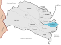
 Калник во Општина Боговиње.svg 1,488 × 1,100; 824 KB
-
 Камењане во Општина Боговиње.svg 1,488 × 1,100; 827 KB
-
 Новаќе во Општина Боговиње.svg 1,488 × 1,100; 822 KB
-
 Ново Село во Општина Боговиње.svg 1,488 × 1,100; 824 KB
-
 Пирок во Општина Боговиње.svg 1,488 × 1,100; 823 KB
-
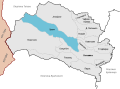
 Раковец во Општина Боговиње.svg 1,488 × 1,100; 827 KB
-
 Селце Кеч во Општина Боговиње.svg 1,488 × 1,100; 823 KB
-
 Синичане во Општина Боговиње.svg 1,488 × 1,100; 824 KB
-
 Урвич во Општина Боговиње.svg 1,488 × 1,100; 825 KB
-
 Чифлик во Општина Боговиње.svg 1,488 × 1,100; 824 KB


