Category:Locator maps of municipalities in Kreis Recklinghausen
Jump to navigation
Jump to search
Kreis Recklinghausen  Castrop-Rauxel · Datteln · Dorsten · Gladbeck · Haltern · Herten · Marl · Marl · Oer-Erkenschwick · Recklinghausen · Waltrop ·
Media in category "Locator maps of municipalities in Kreis Recklinghausen"
The following 11 files are in this category, out of 11 total.
-
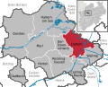
 Castrop-Rauxel in RE.svg 423 × 340; 1.39 MB
-
 Datteln in RE.svg 423 × 340; 1.39 MB
-
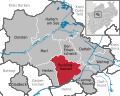
 Dorsten in RE.svg 423 × 340; 1.39 MB
-
 Gladbeck in RE.svg 423 × 340; 1.39 MB
-
 Haltern am See in RE.svg 423 × 340; 1.39 MB
-
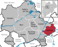
 Herten in RE.svg 423 × 340; 1.39 MB
-
 Marl in RE.svg 423 × 340; 1.39 MB
-
 Municipalities in RE.svg 423 × 340; 1.58 MB
-
 Oer-Erkenschwick in RE.svg 423 × 340; 1.39 MB
-
 Recklinghausen in RE.svg 423 × 340; 1.39 MB
-
 Waltrop in RE.svg 423 × 340; 1.39 MB


