Category:Locator maps of Santa Isabel, Puerto Rico
Jump to navigation
Jump to search
Media in category "Locator maps of Santa Isabel, Puerto Rico"
The following 10 files are in this category, out of 10 total.
-
 Boca Velázquez, Santa Isabel, Puerto Rico locator map.png 1,100 × 1,173; 92 KB
-
 Descalabrado, Santa Isabel, Puerto Rico locator map.png 1,100 × 1,173; 92 KB
-
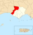
 Felicia 1, Santa Isabel, Puerto Rico locator map.png 1,100 × 1,173; 92 KB
-
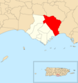
 Felicia 2, Santa Isabel, Puerto Rico locator map.png 1,100 × 1,173; 92 KB
-
 Jauca 1, Santa Isabel, Puerto Rico locator map.png 1,100 × 1,173; 92 KB
-
 Jauca 2, Santa Isabel, Puerto Rico locator map.png 1,100 × 1,173; 92 KB
-
 Locator-map-Puerto-Rico-Santa-Isabel.svg 1,332 × 360; 97 KB
-
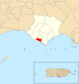 Playa, Santa Isabel, Puerto Rico locator map.png 1,100 × 1,173; 92 KB
-
 Santa Isabel barrio-pueblo, Santa Isabel, Puerto Rico locator map.png 1,100 × 1,173; 92 KB
-
 Santa Isabel, Puerto Rico locator map.png 1,100 × 1,173; 88 KB


