Category:Locator maps of Fajardo, Puerto Rico
Jump to navigation
Jump to search
Media in category "Locator maps of Fajardo, Puerto Rico"
The following 11 files are in this category, out of 11 total.
-
 Cabezas, Fajardo, Puerto Rico locator map.png 1,100 × 1,192; 96 KB
-
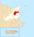
 Demajagua, Fajardo, Puerto Rico locator map.png 1,100 × 1,192; 95 KB
-
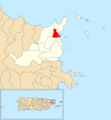
 Fajardo barrio-pueblo, Fajardo, Puerto Rico locator map.png 1,100 × 1,192; 95 KB
-
 Fajardo, Puerto Rico locator map.png 1,100 × 1,192; 136 KB
-
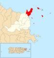
 Florencio, Fajardo, Puerto Rico locator map.png 1,100 × 1,192; 95 KB
-
 Locator-map-Puerto-Rico-Fajardo.svg 1,332 × 360; 97 KB
-
 Naranjo, Fajardo, Puerto Rico locator map.png 1,100 × 1,192; 95 KB
-
 Quebrada Fajardo, Fajardo, Puerto Rico locator map.png 1,100 × 1,192; 95 KB
-
 Quebrada Vueltas, Fajardo, Puerto Rico locator map.png 1,100 × 1,192; 95 KB
-
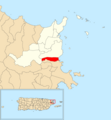
 Río Arriba, Fajardo, Puerto Rico locator map.png 1,100 × 1,192; 95 KB
-
 Sardinera, Fajardo, Puerto Rico locator map.png 1,100 × 1,192; 95 KB


