Category:Locator maps of Espita Municipality
Jump to navigation
Jump to search
Media in category "Locator maps of Espita Municipality"
The following 14 files are in this category, out of 14 total.
-
032 Esperanto Yucatán.png 595 × 470; 18 KB
-
ES-Municipio de Espita.svg 751 × 496; 55 KB
-
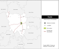
Espita area transportation map-blank.svg 306 × 330; 145 KB
-
Espita area transportation map.svg 306 × 330; 236 KB
-
Espita localidades.svg 300 × 250; 239 KB
-
Espita Municipality Yucatan Espita Highlighted.svg 324 × 151; 195 KB
-
Espita Municipality Yucatan Nacuche Highlighted.svg 324 × 151; 196 KB
-
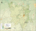
Espita topographic map.svg 512 × 447; 1.13 MB
-
Mapa de Nacuché.svg 461 × 396; 69 KB
-
Mexico Yucatan Espita comunities map.svg 512 × 447; 132 KB
-
Mexico Yucatan Espita location map (urban areas).svg 512 × 419; 102 KB
-
Mexico Yucatan Espita location map.svg 2,815 × 2,211; 1.01 MB
-
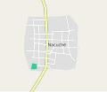
Nacuche street map.svg 237 × 313; 7 KB
-
Yuc, Reg 1, Espita.svg 350 × 210; 63 KB


