Category:Llangamarch
Jump to navigation
Jump to search
parish in Powys, Wales _Gosen_Calvinistic_Methodist_Chapel_on_LHS.jpg)  | |||||
| Upload media | |||||
| Pronunciation audio | |||||
|---|---|---|---|---|---|
| Instance of | |||||
| Location | Powys, Wales | ||||
| Diocese | |||||
| Has part(s) |
| ||||
| Population |
| ||||
| Religion or worldview | |||||
| Different from | |||||
 | |||||
Media in category "Llangamarch"
The following 200 files are in this category, out of 288 total.
(previous page) (next page)-
 A world in miniature - geograph.org.uk - 975972.jpg 640 × 426; 117 KB
-

-
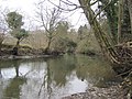
 Afon Irfon - geograph.org.uk - 6335754.jpg 2,048 × 1,536; 1.7 MB
-
 Alexandra Hall, Llangammarch Wells - geograph.org.uk - 5361497.jpg 800 × 525; 82 KB
-
 Arwyddbost Epynt - Epynt signpost - geograph.org.uk - 3129725.jpg 690 × 518; 133 KB
-
 Banc y Cwm - geograph.org.uk - 4385878.jpg 2,288 × 1,712; 1.11 MB
-

-
 Blocked footpath - geograph.org.uk - 6341711.jpg 2,048 × 1,536; 2.06 MB
-
 Blocked footpath at Gwarafog House - geograph.org.uk - 6342388.jpg 1,536 × 2,048; 2.05 MB
-

-
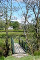
 Bridge of the Llywel road - geograph.org.uk - 1175502.jpg 640 × 427; 193 KB
-

-
 Cammarch Bridge, Llangammarch Wells - geograph.org.uk - 5361435.jpg 800 × 602; 157 KB
-
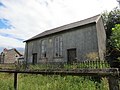
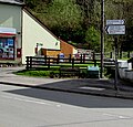
 Capel Gosen Chapel, Cefngorwydd - geograph.org.uk - 3067287.jpg 690 × 518; 165 KB
-
 Capel Hermon Chapel, Tir Abad - geograph.org.uk - 3074743.jpg 690 × 518; 165 KB
-

-
 Catkin display - geograph.org.uk - 6335579.jpg 2,048 × 1,536; 1.36 MB
-
 Cattle Grid on the B4519 - geograph.org.uk - 3433971.jpg 2,529 × 1,776; 1.62 MB
-

-
 Cefn Llwydlo - geograph.org.uk - 5954361.jpg 1,024 × 768; 301 KB
-

-
 Clear fell, Crychan Forest - geograph.org.uk - 976906.jpg 640 × 426; 78 KB
-
 Cnwch, Llangamarch - geograph.org.uk - 3129618.jpg 640 × 480; 93 KB
-

-
 Crychan Forest - geograph.org.uk - 975954.jpg 640 × 426; 86 KB
-
 Cwm Craig-ddu - geograph.org.uk - 4250982.jpg 1,024 × 678; 142 KB
-
 Cyffordd o lwybrau - Junction of paths - geograph.org.uk - 5952429.jpg 1,024 × 768; 289 KB
-
 Cyffordd o traciau - A junction of tracks - geograph.org.uk - 6560766.jpg 1,024 × 768; 224 KB
-
 Derelict pump room at Llangammarch Wells - geograph.org.uk - 3406282.jpg 640 × 480; 177 KB
-
-
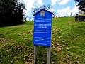
 Distances from Llangammarch Wells, Powys - geograph.org.uk - 5361521.jpg 798 × 800; 102 KB
-
 Distances from Llangammarch Wells, Powys - geograph.org.uk - 5382253.jpg 800 × 780; 127 KB
-

-

-

-
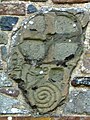 Early Christian Inscribed Stone - geograph.org.uk - 5333712.jpg 968 × 1,290; 370 KB
-
 Edge of the forest - geograph.org.uk - 837740.jpg 427 × 640; 93 KB
-
 Edge of the range - geograph.org.uk - 826114.jpg 640 × 427; 55 KB
-
 Empty moorland - geograph.org.uk - 1179782.jpg 640 × 426; 182 KB
-

-
 Entering Llangammarch Wells - geograph.org.uk - 6225722.jpg 851 × 1,280; 499 KB
-

-
 Esgair Wen - geograph.org.uk - 5579436.jpg 640 × 480; 93 KB
-
 Esgair-wen - geograph.org.uk - 837772.jpg 640 × 427; 59 KB
-
 Fallow forest - geograph.org.uk - 837725.jpg 640 × 427; 73 KB
-
 Farmland near Gelli-crugiau - geograph.org.uk - 975584.jpg 640 × 426; 98 KB
-
 Ffarm Nant Tyrnor - Nant Tyrnor Farm - geograph.org.uk - 5952445.jpg 1,024 × 768; 423 KB
-
 Ffarm Spite Inn - Spite Inn Farm - geograph.org.uk - 5581485.jpg 640 × 480; 115 KB
-
 Ffordd Epynt - The Epynt Way - geograph.org.uk - 3647118.jpg 690 × 518; 168 KB
-
 Ffordd yr Epynt - The Epynt Way - geograph.org.uk - 6058795.jpg 1,024 × 768; 155 KB
-
 Ffordd yr Epynt Way - geograph.org.uk - 3129745.jpg 690 × 518; 169 KB
-
 Ffrwd-wen on Eppynt - geograph.org.uk - 2932667.jpg 640 × 480; 71 KB
-
 Ffrwd-wen on Epynt Ranges - geograph.org.uk - 3433885.jpg 3,648 × 2,736; 3.39 MB
-
 Ffynon Dafydd-Bevan - geograph.org.uk - 1179785.jpg 640 × 427; 188 KB
-
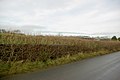
 Field gate and hedge - geograph.org.uk - 6340928.jpg 2,048 × 1,536; 1.35 MB
-
 Field near Llwyn Einon - geograph.org.uk - 1062086.jpg 640 × 428; 223 KB
-
 Footpath through woodland - geograph.org.uk - 6335766.jpg 2,672 × 3,562; 6.11 MB
-

-
 Forest path near Tirabad - geograph.org.uk - 975959.jpg 640 × 426; 107 KB
-
 Forest road, Crychan Forest - geograph.org.uk - 975992.jpg 640 × 426; 98 KB
-
 Forest road, near Tirabad - geograph.org.uk - 975948.jpg 640 × 426; 107 KB
-
 Forestry road, Crychan Forest - geograph.org.uk - 975978.jpg 426 × 640; 99 KB
-
 Fork in the road, Llangammarch Wells - geograph.org.uk - 5361575.jpg 800 × 572; 127 KB
-
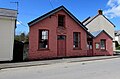
 Former small hotel in Llangammarch Wells - geograph.org.uk - 5382106.jpg 800 × 709; 122 KB
-
 From Pennau - geograph.org.uk - 839368.jpg 640 × 427; 94 KB
-
 From the lane past Penrhiw - geograph.org.uk - 837815.jpg 640 × 411; 70 KB
-
 Gadael y Epynt - Leaving the Epynt - geograph.org.uk - 5579468.jpg 640 × 480; 75 KB
-

-
 Glan-cledan-fach - geograph.org.uk - 1955665.jpg 428 × 640; 182 KB
-
 Grazing land above Aber-cenfydd - geograph.org.uk - 976002.jpg 640 × 426; 87 KB
-
 Grazing land near Tirabad - geograph.org.uk - 977449.jpg 640 × 426; 74 KB
-

-
 Gwar-felin - geograph.org.uk - 837823.jpg 640 × 419; 100 KB
-
 Gwarafog House - geograph.org.uk - 6346479.jpg 2,048 × 1,536; 1.87 MB
-
 Head of Cwm Graig-ddu - geograph.org.uk - 826058.jpg 640 × 427; 72 KB
-

-

-

-
 House near Irfon Bridge - geograph.org.uk - 5516911.jpg 1,024 × 789; 141 KB
-

-
 House on the Llangammarch Wells road - geograph.org.uk - 837841.jpg 640 × 427; 74 KB
-
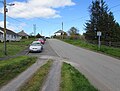
 Houses and cars at Cefn Gorwydd - geograph.org.uk - 4968653.jpg 640 × 480; 138 KB
-

-
 Houses at Tirabad - geograph.org.uk - 1175519.jpg 640 × 427; 193 KB
-
 In Crychan forest - geograph.org.uk - 837763.jpg 427 × 640; 110 KB
-
-

-
 Inside Llangammarch Church - geograph.org.uk - 6225645.jpg 1,280 × 851; 314 KB
-

-
 Irfon river - geograph.org.uk - 6346476.jpg 2,048 × 1,536; 1.52 MB
-

-
 Lane to Caerau - geograph.org.uk - 1173381.jpg 640 × 427; 197 KB
-
 Leaving The Military Training Area, Above Cwm Graig Ddu - geograph.org.uk - 4385871.jpg 2,053 × 1,540; 651 KB
-
 Lichen and leaves - geograph.org.uk - 6335578.jpg 1,536 × 2,048; 920 KB
-
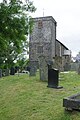 Llangammarch Church - geograph.org.uk - 6225347.jpg 851 × 1,280; 527 KB
-
 Llangammarch Wells - geograph.org.uk - 6221469.jpg 1,280 × 851; 504 KB
-

-
 Llangammarch Wells Depot entrance gates - geograph.org.uk - 5361394.jpg 800 × 720; 123 KB
-
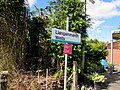
 Llangammarch Wells railway station - geograph.org.uk - 5378716.jpg 800 × 676; 196 KB
-
 Llangammarch Wells railway station - geograph.org.uk - 5516889.jpg 1,024 × 768; 292 KB
-

-
-
 Llangammarch Wells station - geograph.org.uk - 3498138.jpg 640 × 480; 458 KB
-
 Llangammarch Wells Station - geograph.org.uk - 5598848.jpg 1,024 × 768; 148 KB
-

-
 Llwybr Abererbwll - Abererbwll Path - geograph.org.uk - 6058782.jpg 1,024 × 768; 292 KB
-
 Llwybr Abererbwll - Abererbwll Path - geograph.org.uk - 6058789.jpg 1,024 × 768; 317 KB
-
 Llwybr ceffyl Aber Annell Fach Bridleway - geograph.org.uk - 3129839.jpg 690 × 518; 231 KB
-

-
 Llwybr ceffyl Abergefail - Abergefail bridleway - geograph.org.uk - 5952341.jpg 1,024 × 768; 283 KB
-

-

-

-

-

-
 Llwybr Ceffyl Llangamarch Bridleway - geograph.org.uk - 3641956.jpg 690 × 518; 226 KB
-
 Llwybr Cnwch Path - geograph.org.uk - 3129659.jpg 690 × 518; 181 KB
-
 Llwybr ger Gledrydd - Path near Gledrydd - geograph.org.uk - 6058796.jpg 1,024 × 768; 188 KB
-
 Llwybr ger Gledrydd - Path near Gledrydd - geograph.org.uk - 6058797.jpg 1,024 × 768; 188 KB
-

-
-
 Llwybr Troed y Rhiw Isaf path - geograph.org.uk - 3129817.jpg 690 × 518; 196 KB
-
 Llwybr Ty Bach - Ty Bach Footpath - geograph.org.uk - 5579489.jpg 640 × 480; 132 KB
-

-
 Look at all those green squares - geograph.org.uk - 837958.jpg 640 × 427; 87 KB
-
 Mabbion Way - geograph.org.uk - 826090.jpg 640 × 427; 66 KB
-
 Mabioin Way plaque - geograph.org.uk - 837663.jpg 640 × 427; 87 KB
-
 Master of all I survey - geograph.org.uk - 837649.jpg 640 × 427; 59 KB
-
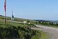
 Military use only - geograph.org.uk - 826278.jpg 640 × 427; 74 KB
-
 Mist above Cwm Graig ddû - geograph.org.uk - 980705.jpg 640 × 426; 23 KB
-
 Mist above Llangammarch Wells - geograph.org.uk - 980727.jpg 640 × 426; 62 KB
-
 Misty Cwm Graig Ddu - geograph.org.uk - 980698.jpg 426 × 640; 34 KB
-
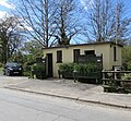
 Moorland depot - geograph.org.uk - 1179787.jpg 640 × 427; 204 KB
-
 Moorland near B4519 - geograph.org.uk - 839665.jpg 640 × 427; 64 KB
-
 Moorland Stream At Cefniolo - geograph.org.uk - 5612997.jpg 1,600 × 1,200; 392 KB
-
 Mynd i mewn i Bowys - Entering Powys - geograph.org.uk - 6058801.jpg 1,024 × 768; 250 KB
-
 Mynydd Epynt - geograph.org.uk - 6335734.jpg 2,048 × 1,536; 1.83 MB
-
 Nant Bran - geograph.org.uk - 1179789.jpg 640 × 427; 208 KB
-
 Nant Bran - geograph.org.uk - 1179790.jpg 640 × 427; 179 KB
-

-
 Near Gwibedog - geograph.org.uk - 1173405.jpg 640 × 426; 192 KB
-
 Near Gwibedog - geograph.org.uk - 1175488.jpg 640 × 426; 176 KB
-
 Near Gwibedog - geograph.org.uk - 1175493.jpg 640 × 428; 189 KB
-
 Near Nant Annell - geograph.org.uk - 837818.jpg 640 × 427; 93 KB
-
 Nice view if you have the time - geograph.org.uk - 837733.jpg 640 × 427; 62 KB
-
 North of Park farm - geograph.org.uk - 837947.jpg 640 × 428; 73 KB
-

-

-
 Off the Mabbion Way - geograph.org.uk - 837694.jpg 640 × 427; 116 KB
-
 Off the Mabbions Way - geograph.org.uk - 837688.jpg 640 × 427; 122 KB
-
 Off the scarp - geograph.org.uk - 837633.jpg 427 × 640; 93 KB
-
 Off the scarp - geograph.org.uk - 837645.jpg 640 × 427; 75 KB
-
 Old quarry - geograph.org.uk - 837800.jpg 640 × 427; 112 KB
-
 On Llethr Ddu - geograph.org.uk - 837659.jpg 640 × 427; 77 KB
-
 On the Epynt Way - geograph.org.uk - 837640.jpg 640 × 427; 100 KB
-
 On the Epynt Way - geograph.org.uk - 837683.jpg 640 × 414; 88 KB
-
 Onto the range - geograph.org.uk - 837671.jpg 640 × 427; 54 KB
-
 Open area in Crychan Forest - geograph.org.uk - 975986.jpg 640 × 426; 109 KB
-
 Opposite Penlanwen - geograph.org.uk - 1175532.jpg 640 × 426; 152 KB
-
 Ordnance Survey Cut Mark - geograph.org.uk - 3800086.jpg 480 × 640; 96 KB
-
 Ordnance Survey Cut Mark - geograph.org.uk - 3800090.jpg 480 × 640; 81 KB
-
 Ordnance Survey Cut Mark - geograph.org.uk - 3801510.jpg 480 × 640; 100 KB
-
 Ordnance Survey Cut Mark - geograph.org.uk - 5299461.jpg 640 × 339; 60 KB
-
 Ordnance Survey Cut Mark - geograph.org.uk - 5299462.jpg 640 × 367; 92 KB
-
 Ordnance Survey Flush Bracket (S0789) - geograph.org.uk - 3800077.jpg 480 × 640; 122 KB
-
 Ordnance Survey Rivet - geograph.org.uk - 3801523.jpg 640 × 480; 117 KB
-
 Outskirts of Llangammarch Wells - geograph.org.uk - 837953.jpg 640 × 427; 74 KB
-
 Park farm - geograph.org.uk - 826180.jpg 640 × 427; 83 KB
-

-

-

-
 Pasture above Crychan forest - geograph.org.uk - 1177809.jpg 640 × 427; 195 KB
-
 Pasture below Crychan Forest - geograph.org.uk - 1175546.jpg 640 × 427; 167 KB
-
 Pasture near Llangammarch Wells - geograph.org.uk - 826195.jpg 640 × 427; 95 KB
-
 Penlanwen - geograph.org.uk - 5952285.jpg 1,024 × 768; 246 KB
-
 Phone mast at Cefn-gorwydd - geograph.org.uk - 1048609.jpg 480 × 640; 47 KB
-
 Picnic area Crychan Forest - geograph.org.uk - 975575.jpg 640 × 426; 95 KB
-

-

-
 Problems with the drainage - geograph.org.uk - 837653.jpg 640 × 427; 114 KB
-
-
 Reservoir in Cwm Syfien - geograph.org.uk - 838117.jpg 640 × 427; 123 KB
-
 Reservoir in Cwm Syfien - geograph.org.uk - 838123.jpg 640 × 427; 116 KB
-

-
 River Irfon at Llangammarch Wells - geograph.org.uk - 1254016.jpg 640 × 480; 99 KB
-
 River Irfon near Llangammarch Wells - geograph.org.uk - 3363671.jpg 640 × 480; 109 KB
-
 River Irfon, Llangammarch Wells, Powys - geograph.org.uk - 5382933.jpg 800 × 600; 205 KB
-
 River Irfon, Llangammarch Wells, Powys - geograph.org.uk - 5382945.jpg 800 × 600; 226 KB
-

-
 Riverside at Llangammarch Wells - geograph.org.uk - 6335564.jpg 2,048 × 1,536; 1.94 MB
-

-

-
 Riverside oak tree - geograph.org.uk - 6335581.jpg 2,048 × 1,536; 2.21 MB
-
-
 Road at Llwyn Einon - geograph.org.uk - 1062095.jpg 640 × 428; 149 KB
-
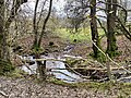
 Road bridge and stream - geograph.org.uk - 6340921.jpg 2,048 × 1,536; 2.05 MB
-
 Road near Llwyn Einon - geograph.org.uk - 1062090.jpg 640 × 428; 156 KB
-
 Road to Upper Chapel and Brecon off the B4519 - geograph.org.uk - 3433983.jpg 2,798 × 2,233; 1.92 MB
-

-


_station_-_geograph.org.uk_-_5378730.jpg)


_-_geograph.org.uk_-_3129800.jpg)


_-_geograph.org.uk_-_3800077.jpg)


