Category:Little Hayfield
Jump to navigation
Jump to search
hamlet in High Peak, Derbyshire, England  | |||||
| Upload media | |||||
| Instance of | |||||
|---|---|---|---|---|---|
| Location | Hayfield, High Peak, Derbyshire, East Midlands, England | ||||
 | |||||
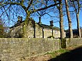
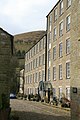
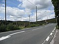
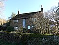
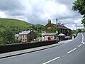
English: Little Hayfield is a hamlet in the Peak District National Park, in England. It lies on the A624 between Hayfield and Glossop. Its main point of interest is the Lantern Pike pub. Sheepdog trials and fell racing take place there.
Media in category "Little Hayfield"
The following 75 files are in this category, out of 75 total.
-
 "Lantern Pike Inn", Little Hayfield - geograph.org.uk - 5087065.jpg 4,978 × 3,572; 3.9 MB
-
 A White Tailed Sea Eagle takes to the sky - geograph.org.uk - 3665341.jpg 4,081 × 2,468; 1.98 MB
-
 A624 at Little Hayfield - geograph.org.uk - 1479815.jpg 640 × 480; 49 KB
-
 A624 Glossop Road at Marl House farm - geograph.org.uk - 1479818.jpg 640 × 480; 81 KB
-

-
 Barn at Ivy Farm, Little Hayfield.jpg 4,052 × 3,070; 1.36 MB
-
 Barn at Marl House, Little Hayfield.jpg 4,000 × 3,000; 2.17 MB
-
 Betty the Ruppel's Griffon Vulture - geograph.org.uk - 3665328.jpg 3,456 × 4,608; 3.68 MB
-

-

-
 Brook House Barn.jpg 4,000 × 3,000; 4.9 MB
-
 Brookhouse Farm - geograph.org.uk - 2769344.jpg 4,000 × 3,000; 2.65 MB
-
 Brookhouse Farm - geograph.org.uk - 4501423.jpg 5,184 × 3,456; 1.69 MB
-
 Brookhouses - geograph.org.uk - 4305410.jpg 1,800 × 1,350; 568 KB
-
 Brookhouses - geograph.org.uk - 4305418.jpg 1,800 × 1,350; 538 KB
-
 Brookhouses Farm - geograph.org.uk - 80912.jpg 640 × 480; 161 KB
-
 Brookhouses.jpg 4,000 × 3,000; 4.8 MB
-
 Carr Meadow - geograph.org.uk - 4331772.jpg 1,800 × 1,350; 491 KB
-
 Carr Meadow Cottages - geograph.org.uk - 4329699.jpg 1,800 × 1,350; 580 KB
-
 Carr Meadow Cottages.jpg 4,000 × 3,000; 4.7 MB
-
 Clever Dog! - geograph.org.uk - 3665304.jpg 3,578 × 2,671; 1.97 MB
-
 Clough leading down to Little Hayfield - geograph.org.uk - 2178485.jpg 3,872 × 2,592; 1.68 MB
-
 Clough Mill - Little Hayfield - geograph.org.uk - 2596100.jpg 4,000 × 3,000; 3.99 MB
-
 Clough Mill and Little Hayfield - geograph.org.uk - 4301672.jpg 1,350 × 1,800; 748 KB
-
 Clough Mill, Little Hayfield - geograph.org.uk - 1205355.jpg 427 × 640; 79 KB
-
 Clough Mill, Little Hayfield - geograph.org.uk - 2730061.jpg 640 × 427; 76 KB
-
 Clough Mill, Little Hayfield - geograph.org.uk - 2730068.jpg 640 × 427; 76 KB
-
 Clough Mill, Little Hayfield - geograph.org.uk - 2730071.jpg 640 × 427; 81 KB
-
 Cottages at Brookhouses - geograph.org.uk - 5086763.jpg 5,000 × 3,630; 5.29 MB
-
 East from Lantern Pike - geograph.org.uk - 221604.jpg 640 × 480; 262 KB
-
 Estate Agents' signs, Lanehead Road - geograph.org.uk - 2769340.jpg 4,000 × 3,000; 2.57 MB
-
 Farmland, north of Little Hayfield - geograph.org.uk - 2769359.jpg 4,000 × 3,000; 2.54 MB
-
 Footbridge at Carr Meadow - geograph.org.uk - 4331755.jpg 1,800 × 1,350; 470 KB
-
 Footbridge, Hollingworth Clough - geograph.org.uk - 2769338.jpg 4,000 × 3,000; 2.45 MB
-
 Footpath sign on Lanehead Road - geograph.org.uk - 5086767.jpg 4,985 × 3,739; 5.89 MB
-
 Glossop Road (A624) - geograph.org.uk - 1950005.jpg 640 × 480; 65 KB
-
 Hay barn at Marl House, Little Hayfield.jpg 4,000 × 3,000; 1.82 MB
-
 Hayfield County Show - geograph.org.uk - 3669712.jpg 640 × 427; 284 KB
-
 Hey Brows from Monk's Road - geograph.org.uk - 221616.jpg 640 × 480; 225 KB
-
 Ivy Farmhouse, Little Hayfield (rear).jpg 4,000 × 3,000; 5.05 MB
-
 Ivy Farmhouse, Little Hayfield.jpg 4,103 × 3,138; 1.76 MB
-
 Junction of paths near Blackshaw Farm - geograph.org.uk - 5086765.jpg 4,629 × 3,622; 4 MB
-
 Kinder Scout and Little Hayfield from Lantern Pike - geograph.org.uk - 1734045.jpg 3,872 × 2,592; 3.26 MB
-
 Landscape of Little Hayfield - panoramio (1).jpg 2,304 × 1,536; 714 KB
-
 Landscape of Little Hayfield - panoramio.jpg 2,304 × 1,728; 705 KB
-
 Lane Passing Brookhouse Farm - geograph.org.uk - 2819099.jpg 3,202 × 2,340; 1.37 MB
-
 Lantern Pike - geograph.org.uk - 4501421.jpg 4,601 × 2,538; 1.75 MB
-
 Little Hayfield - geograph.org.uk - 2769361.jpg 4,000 × 3,000; 2.49 MB
-
 Little Hayfield - geograph.org.uk - 3407112.jpg 640 × 480; 99 KB
-
 Little Hayfield 0525.jpg 2,592 × 1,944; 1.21 MB
-
 Little Hayfield from the southwest - geograph.org.uk - 55406.jpg 640 × 480; 172 KB
-
 LittleHayfield.JPG 2,048 × 1,536; 1.07 MB
-
 Marl House from Lantern Pike.jpg 4,000 × 3,000; 2.03 MB
-
 Meeting of six paths near Blackshaw Farm - geograph.org.uk - 2827640.jpg 3,872 × 2,592; 5.26 MB
-
 Middle Moor - geograph.org.uk - 222310.jpg 640 × 480; 251 KB
-
 Middle Moor and Sandy Heys - geograph.org.uk - 43602.jpg 640 × 480; 144 KB
-
 Mighty Smith the Strong Man - Hayfield Country Show - geograph.org.uk - 3665348.jpg 3,815 × 2,931; 2.24 MB
-
 On a lane to Blackshaw Farm - geograph.org.uk - 2769348.jpg 4,000 × 3,000; 2.48 MB
-

-
 On the lane from Little Hayfield. - geograph.org.uk - 2417619.jpg 480 × 640; 94 KB
-
 Park Hall Entrance - geograph.org.uk - 40282.jpg 640 × 480; 223 KB
-
 Park Hall Stables - geograph.org.uk - 55409.jpg 640 × 480; 187 KB
-
 Park Hall, Little Hayfield.jpg 4,000 × 3,000; 886 KB
-
 Pennine Bridleway near Matleymoor Farm - geograph.org.uk - 957940.jpg 640 × 480; 140 KB
-
 Roxy the White Tailed Sea Eagle - geograph.org.uk - 3665316.jpg 2,736 × 3,648; 2.26 MB
-
 Stable block at Park Hall, Little Hayfield.jpg 4,000 × 3,000; 4.66 MB
-
 Start of the bridleway - geograph.org.uk - 1079570.jpg 640 × 480; 120 KB
-
 The A624 Glossop Road - geograph.org.uk - 3665285.jpg 2,175 × 1,645; 894 KB
-
 The edge of Middle Moor - geograph.org.uk - 1026367.jpg 640 × 480; 128 KB
-
 The Lantern Pike Public House - geograph.org.uk - 2519052.jpg 3,296 × 2,472; 1.06 MB
-
 The Mighty Smith at Hayfield Country Show - geograph.org.uk - 3665352.jpg 2,213 × 4,608; 2.27 MB
-
 The Mill at Little Hayfield - geograph.org.uk - 2769368.jpg 4,000 × 3,000; 2.65 MB
-

-
 Towards The Knott - geograph.org.uk - 222366.jpg 480 × 640; 296 KB
-
 View from the Beer Tent - Hayfield Country Show - geograph.org.uk - 3665335.jpg 4,608 × 2,913; 3.05 MB


_-_geograph.org.uk_-_1950005.jpg)


.jpg)


.jpg)


