Category:Little Blue River (Nebraska and Kansas)
Jump to navigation
Jump to search
river in Nebraska and Kansas, United States  | |||||
| Upload media | |||||
| Instance of | |||||
|---|---|---|---|---|---|
| Location | |||||
| Length |
| ||||
| Elevation above sea level |
| ||||
| Mouth of the watercourse | |||||
| Drainage basin |
| ||||
 | |||||
English: Media related to the Little Blue River (Kansas/Nebraska), a river in Nebraska and Kansas in the United States, that is a tributary of the Big Blue River.
[[Category:Kansas
Subcategories
This category has the following 2 subcategories, out of 2 total.
A
- Ayr, Nebraska (7 F)
H
Media in category "Little Blue River (Nebraska and Kansas)"
The following 4 files are in this category, out of 4 total.
-

-
 Little Blue River at Oak Mill DS.JPG 2,560 × 1,431; 1.68 MB
-
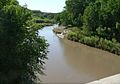 Little Blue River at Oak Mill US.JPG 2,256 × 1,573; 1.44 MB
-
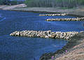 NRCSKS02100 - Kansas (4381)(NRCS Photo Gallery).jpg 2,100 × 1,500; 6.59 MB


(NRCS_Photo_Gallery).jpg)
Categories:
- Rivers of Kansas
- Rivers of Nebraska
- Geography of Kearney County, Nebraska
- Geography of Franklin County, Nebraska
- Geography of Webster County, Nebraska
- Geography of Adams County, Nebraska
- Geography of Clay County, Nebraska
- Geography of Nuckolls County, Nebraska
- Geography of Thayer County, Nebraska
- Geography of Jefferson County, Nebraska
- Geography of Washington County, Kansas
- Geography of Marshall County, Kansas
- Big Blue River (Kansas-Nebraska)
- Rivers of the United States by name
- Locations along U.S. Route 36 in Kansas
- Locations along U.S. Route 81 in Nebraska
- Locations along U.S. Route 136 in Nebraska
- Locations along U.S. Route 281 in Nebraska
- Locations along K-148 (Kansas highway)
- Locations along Nebraska Highway 4
- Locations along Nebraska Highway 5
- Locations along Nebraska Highway 8
- Locations along Nebraska Highway 14
- Locations along Nebraska Highway 15
- Locations along Nebraska Highway 53
- Locations along Nebraska Highway 74
- Locations along Nebraska Spur 18C