Category:Level crossings on the Hull and Selby Railway (Bridlington branch)
Jump to navigation
Jump to search
Subcategories
This category has the following 3 subcategories, out of 3 total.
Media in category "Level crossings on the Hull and Selby Railway (Bridlington branch)"
The following 39 files are in this category, out of 39 total.
-
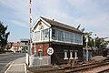 2019 at Beverley station - signal box (front).JPG 1,366 × 910; 483 KB
-
 2019 at Beverley station - signal box (rear).JPG 1,366 × 910; 459 KB
-
 Beverley Station IMG 4024 - panoramio.jpg 1,800 × 903; 566 KB
-
 Burton Agnes Level Crossing - geograph.org.uk - 1256525.jpg 640 × 480; 50 KB
-
 Burton Agnes level crossing.jpg 640 × 480; 101 KB
-
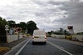 Carnaby Level Crossing - geograph.org.uk - 1412117.jpg 640 × 423; 46 KB
-
 Carnaby Level Crossing.jpg 640 × 398; 54 KB
-
 Cottingham - Level Crossing - geograph.org.uk - 41669.jpg 640 × 480; 144 KB
-
 Crossing East of Harpham - geograph.org.uk - 142930.jpg 640 × 480; 151 KB
-
 Crossing NE of Nafferton - geograph.org.uk - 252276.jpg 640 × 480; 102 KB
-
 Crossing over rail lines near Black House Farm (geograph 5100140).jpg 1,600 × 1,065; 860 KB
-
 Crossing the tracks (geograph 6516390).jpg 3,648 × 1,744; 3.07 MB
-
 Footpath Approaching Railway.jpg 640 × 480; 122 KB
-
 Harpham Crossing - geograph.org.uk - 462827.jpg 471 × 640; 114 KB
-
 Harpham Crossing - geograph.org.uk - 462833.jpg 473 × 640; 163 KB
-
 Hull - Scarborough Railway - geograph.org.uk - 1408965.jpg 640 × 442; 99 KB
-
 Kilnwick Level Crossing - geograph.org.uk - 46092.jpg 640 × 480; 114 KB
-
 Level Crossing - geograph.org.uk - 1102521.jpg 640 × 477; 117 KB
-
 Level Crossing - geograph.org.uk - 72582.jpg 640 × 480; 50 KB
-
 Level Crossing near Beverley Station - geograph.org.uk - 798552.jpg 640 × 518; 91 KB
-
 Level Crossing on Flemingate (B1230) - geograph.org.uk - 800284.jpg 640 × 425; 87 KB
-
 Level crossing, Flemingate - geograph.org.uk - 1774951.jpg 640 × 480; 114 KB
-
 Level Crossing, Wilfholme Road - geograph.org.uk - 1454109.jpg 640 × 480; 83 KB
-
 Lockington Crossing - geograph.org.uk - 46003.jpg 640 × 480; 89 KB
-
 Nethergate Level Crossing - geograph.org.uk - 1302293.jpg 640 × 480; 87 KB
-
 Railway at Beverley - geograph.org.uk - 1102660.jpg 480 × 640; 85 KB
-
 Railway line to Beverley - geograph.org.uk - 1516562.jpg 640 × 427; 359 KB
-
 Railway Line to Bridlington. - geograph.org.uk - 530190.jpg 640 × 453; 87 KB
-
 Railway Station looking north - geograph.org.uk - 385307.jpg 640 × 480; 144 KB
-
 Railway to Driffield and Scarborough - geograph.org.uk - 1516604.jpg 640 × 427; 325 KB
-
 Station Farm - geograph.org.uk - 1516572.jpg 640 × 427; 310 KB
-
 Station Farm and the Level Crossing - geograph.org.uk - 1516557.jpg 640 × 427; 320 KB
-
 Station Road, Cottingham - geograph.org.uk - 879304.jpg 479 × 640; 114 KB
-

-
 Thwaite St Cottingham IMG 8973 - panoramio.jpg 1,600 × 1,067; 841 KB
-
 Track to Harpham - geograph.org.uk - 142936.jpg 640 × 480; 123 KB
-
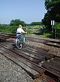
 Track to level crossing and Park Grange Farm (geograph 3362034).jpg 640 × 480; 61 KB
-
 Unmanned Level Crossing Haisthorpe.jpg 640 × 480; 76 KB
-

.JPG)
.JPG)


.jpg)
.jpg)


_-_geograph.org.uk_-_800284.jpg)


.jpg)

