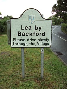
Category:Lea by Backford
Jump to navigation
Jump to search
hamlet and civil parish in the unitary authority of Cheshire West and Chester and the ceremonial county of Cheshire, England | |||||
| Upload media | |||||
| Instance of | |||||
|---|---|---|---|---|---|
| Location | Cheshire West and Chester, Cheshire, North West England, England | ||||
| Population |
| ||||
 | |||||
Lea-by-Backford is a hamlet and civil parish in the unitary authority of Cheshire West and Chester and the ceremonial county of Cheshire, England. It is situated between Chester and Ellesmere Port, west of the A41 trunk road and to the north of the Shropshire Union Canal. Map
Media in category "Lea by Backford"
The following 37 files are in this category, out of 37 total.
-
A5117 at Dunkirk industrial estate - geograph.org.uk - 4454355.jpg 640 × 379; 111 KB
-
Bend in Station Road towards Mollington - geograph.org.uk - 6184801.jpg 800 × 600; 127 KB
-
Bridle Lane, Lea-by-Backford - geograph.org.uk - 3314536.jpg 4,000 × 3,000; 4.39 MB
-
Chaos out of chaos, 2021. (51446391819).jpg 5,268 × 2,634; 13.79 MB
-
Cheshire jungle, UK, 2021. (51095214568).jpg 3,888 × 3,888; 23.18 MB
-
Cheshire West and Chester, UK - panoramio - IIya Kuzhekin.jpg 4,000 × 2,250; 2.73 MB
-
Coalpit Lane near Lea-by-Backford - geograph.org.uk - 3314432.jpg 4,000 × 3,000; 3.33 MB
-
Costco Chester store - geograph.org.uk - 4454356.jpg 640 × 499; 58 KB
-
Country lane, Lea-by-Backford, Cheshire, UK, 2024. - Flickr - Phlips photos.jpg 5,879 × 3,674; 3.34 MB
-
Cut Mark, Railway Bridge, Lea by Backford - geograph.org.uk - 2275601.jpg 3,648 × 2,736; 3.92 MB
-
Cut silage field near Lea Farm - geograph.org.uk - 6184799.jpg 800 × 600; 86 KB
-
Cut silage field off Station Road - geograph.org.uk - 6184796.jpg 800 × 583; 105 KB
-
Demage Lane, Mollington - geograph.org.uk - 3314334.jpg 4,000 × 3,000; 4.27 MB
-
Disused Lane near Lea-by-Backford - geograph.org.uk - 3314462.jpg 4,000 × 3,000; 2.88 MB
-
End of M56 westbound - geograph.org.uk - 2762891.jpg 640 × 480; 43 KB
-
Entrance to Bridle Lane at Lea-by-Backford - geograph.org.uk - 3314544.jpg 4,860 × 3,437; 2.17 MB
-
Junction of Grove Road and Coalpit Lane, Lea-by-Backford - geograph.org.uk - 3314425.jpg 4,000 × 3,000; 2.8 MB
-
Lea-by-Backford, Cheshire, UK, 2021. (51446643868).jpg 3,209 × 1,404; 3.79 MB
-
M56 motorway ahead - geograph.org.uk - 2252516.jpg 640 × 480; 50 KB
-
M56 Motorway approaching Acres Wood - geograph.org.uk - 2252526.jpg 640 × 480; 50 KB
-
M56 westbound approaches its end - geograph.org.uk - 2786489.jpg 640 × 480; 24 KB
-
Mollington, Backford & District Village Hall - DSC06900.JPG 3,648 × 2,736; 3.58 MB
-
National Cycle Route 56 near Lea-by-Backford - geograph.org.uk - 3314501.jpg 4,000 × 3,000; 2.5 MB
-
Natures detail, Lea-by-Backford, Cheshire, UK, 2021. (51489154681).jpg 3,883 × 2,184; 7.75 MB
-
Path to Station Road - geograph.org.uk - 3263360.jpg 1,600 × 1,066; 677 KB
-
Railway towards Birkenhead - geograph.org.uk - 6184798.jpg 800 × 600; 153 KB
-
Shropshire Union Canal and towpath - geograph.org.uk - 2998779.jpg 4,000 × 3,000; 2.71 MB
-
Sign, Lea-by-Backford, Cheshire - DSC06894.JPG 2,736 × 3,648; 3.61 MB
-
Sign, Lea-by-Backford, Cheshire - DSC06895.JPG 3,648 × 2,736; 3.6 MB
-
Station Road, Backford - geograph.org.uk - 6184797.jpg 800 × 600; 92 KB
-
The Chester to Birkenhead Railway Line heading North - geograph.org.uk - 3314368.jpg 3,725 × 2,635; 2.64 MB
-
The Chester to Birkenhead Railway Line heading South - geograph.org.uk - 3314388.jpg 3,815 × 2,695; 2.97 MB
-
Westbound M56 near Dunkirk - geograph.org.uk - 5610925.jpg 640 × 427; 328 KB
-
Wood Farm near Lea-by-Backford - geograph.org.uk - 3314476.jpg 5,000 × 3,750; 2.32 MB


