Category:Land use diagrams
Jump to navigation
Jump to search
| NO WIKIDATA ID FOUND! Search for Land use diagrams on Wikidata | |
| Upload media |
Media in category "Land use diagrams"
The following 49 files are in this category, out of 49 total.
-
Agricultural area over the long-term, OWID.svg 850 × 600; 31 KB
-
Agricultural-labor-land (OWID 0030).png 850 × 600; 91 KB
-
Agriculture-land-fao (OWID 0020).png 850 × 600; 38 KB
-
Arable land use per person, OWID.svg 850 × 600; 21 KB
-
Arable-land-pin (OWID 0090).png 850 × 600; 57 KB
-
Area-per-tonne-oil (OWID 0088).png 850 × 600; 61 KB
-
Causas del cambio de uso de suelo .png 622 × 484; 57 KB
-
Cereal-distribution-to-uses (OWID 0113).png 850 × 600; 63 KB
-
Cereal-land-spared (OWID 0114).png 850 × 600; 58 KB
-
Cereals-human-food-vs-gdp (OWID 0167).png 850 × 600; 120 KB
-
Cropland-pasture-per-person (OWID 0232).png 850 × 600; 53 KB
-
Food-, land-, and climate change mitigation-gaps for 2050.jpg 2,813 × 719; 329 KB
-
Food-emissions-production-supply-chain (OWID 0422).png 850 × 600; 75 KB
-
Global agricultural land use by major crop type, OWID.svg 850 × 600; 13 KB
-
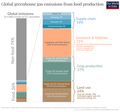
Global greenhouse gas emissions from food production.png 1,624 × 1,520; 155 KB
-
Global-cropland (OWID 0463).png 850 × 600; 60 KB
-
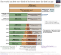
Global-forest-loss-since-ice-age 3618.png 3,618 × 2,066; 235 KB
-
Global-land-use-graphic.png 6,251 × 3,951; 560 KB
-
Global-land-use-since-10000bc (OWID 0541).png 850 × 600; 52 KB
-
Global-land-use-since-1000bc (OWID 0540).png 850 × 600; 53 KB
-
Global-pasture (OWID 0535).png 850 × 600; 59 KB
-
Global-peak-agricultural-land (OWID 0532).png 850 × 600; 68 KB
-
Globaler Fußabdruck je Einwohner.jpg 1,246 × 1,571; 367 KB
-
Grazing land use over the long-term, OWID.svg 850 × 600; 31 KB
-
Land Use of Energy Sources per Unit of Electricity.png 1,937 × 1,791; 270 KB
-
Land use-induced zoonotic spillover and ecological countermeasures.webp 1,774 × 921; 95 KB
-
Land-natural-share (OWID 0594).png 850 × 600; 69 KB
-
Land-use (OWID 0580).png 850 × 600; 33 KB
-
Land-use-agriculture-longterm (OWID 0589).png 850 × 600; 45 KB
-
Land-use-for-vegetable-oil-crops (OWID 0588).png 850 × 600; 76 KB
-
Land-use-of-different-diets-Poore-Nemecek.png 2,048 × 1,259; 1.12 MB
-
Land-use-over-the-long-term (OWID 0584).png 850 × 600; 47 KB
-
Land-use-per-kg-poore (OWID 0586).png 850 × 600; 75 KB
-
Land-use-per-kg-poore.png 3,400 × 2,400; 639 KB
-
Land-use-protein-poore (OWID 0583).png 850 × 600; 60 KB
-
Land-use-seafood (OWID 0582).png 850 × 600; 75 KB
-
Land-use-vs-yield-change-in-cereal-production (OWID 0581).png 850 × 600; 92 KB
-
Landusepiechart.png 537 × 501; 109 KB
-
Long-term-change-in-land-use.png 3,214 × 2,900; 501 KB
-
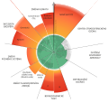
PBs2023-cs.svg 512 × 484; 126 KB
-
PBs2023-de.svg 1,318 × 1,241; 242 KB
-
PBs2023.svg 1,279 × 1,234; 310 KB
-
Rabbitlca Graphical Abstract 5.jpg 1,280 × 720; 224 KB
-
Suitable land, land in use and surplus land in 2010, 2020 and 2030.png 1,970 × 754; 663 KB
-
Total-agricultural-area-over-the-long-term (OWID 1038).png 850 × 600; 88 KB
-
Total-agricultural-land-use-per-person (OWID 1037).png 850 × 600; 49 KB


