Category:Land drainage pumping stations in Lincolnshire
Jump to navigation
Jump to search
Subcategories
This category has the following 6 subcategories, out of 6 total.
D
- Dogdyke pumping station (24 F)
K
- Keadby Pumping Station (6 F)
P
- Pinchbeck Engine (13 F)
U
- Upper Witham IDB (6 F)
Media in category "Land drainage pumping stations in Lincolnshire"
The following 41 files are in this category, out of 41 total.
-
 Anderby Pump - geograph.org.uk - 240193.jpg 640 × 415; 85 KB
-

-
 Black Bank Pumping Station - geograph.org.uk - 458027.jpg 640 × 427; 72 KB
-
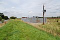
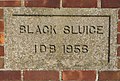
 Black Sluice pumping station - geograph.org.uk - 1743180.jpg 2,736 × 3,648; 2.15 MB
-
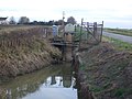
 Bridge over New River (Drain) (geograph 3081485).jpg 1,024 × 768; 162 KB
-
 Birdhouse Clough Pumping Station - geograph.org.uk - 339510.jpg 640 × 360; 108 KB
-
 Broughton Pumping Station - geograph.org.uk - 1417612.jpg 640 × 604; 187 KB
-
 BullHassocksPumpingStationHatfieldChase.jpg 2,272 × 1,704; 856 KB
-
 Pumping Station - geograph.org.uk - 514565.jpg 640 × 426; 115 KB
-
 Thirty Foot Drain Pumping Station - geograph.org.uk - 516085.jpg 640 × 454; 109 KB
-
 Bewcarrs Pumping Station. - geograph.org.uk - 873219.jpg 640 × 480; 97 KB
-
 Archimedes Screw Drainage Water pump - geograph.org.uk - 1216671.jpg 640 × 480; 74 KB
-
 Detail on pumping station - geograph.org.uk - 702900.jpg 640 × 430; 77 KB
-
 Dirtness Pumping Station - geograph.org.uk - 140532.jpg 640 × 480; 81 KB
-
 DirtnessPumpingStationHatfieldChase.jpg 2,272 × 1,704; 874 KB
-

-
 Dowsby Fen Pumping Station, Lincs - geograph.org.uk - 243939.jpg 640 × 480; 318 KB
-
 Drainage pump - geograph.org.uk - 702885.jpg 640 × 470; 82 KB
-

-
 Greenholme Pumping Station - geograph.org.uk - 1578951.jpg 640 × 426; 59 KB
-
 HatfieldChaseKeadbyPumpingStation.jpg 2,272 × 1,704; 874 KB
-
 LadeBankPumpingStation.jpg 640 × 427; 50 KB
-

-

-
 Pinchbeck Pumping Station - geograph.org.uk - 1758060.jpg 640 × 426; 131 KB
-
 Pumping Station - geograph.org.uk - 691997.jpg 640 × 480; 78 KB
-
 Pumping Station near Bleak House Farm - geograph.org.uk - 430173.jpg 640 × 477; 87 KB
-
 Pumping station on Carr Dyke - geograph.org.uk - 702891.jpg 640 × 480; 98 KB
-
 Pumping Station on Skerth Drain - geograph.org.uk - 548738.jpg 640 × 480; 64 KB
-

-
 Pumping Station, Cowbit Wash, Lincs - geograph.org.uk - 51873.jpg 640 × 480; 274 KB
-
 Redbourne Hayes pumping station - geograph.org.uk - 1688988.jpg 3,374 × 1,934; 4.63 MB
-
 Risegate Eau Pumping Station - geograph.org.uk - 432379.jpg 640 × 477; 90 KB
-
 South Kelsey pumping station - geograph.org.uk - 1162388.jpg 640 × 406; 83 KB
-
 Lord's Drain Pumping Station - geograph.org.uk - 183924.jpg 640 × 427; 107 KB
-
 Thoresby Bridge Pumping Station - geograph.org.uk - 680136.jpg 640 × 427; 68 KB
-
 Thorpe Culvert Pumping Station - geograph.org.uk - 1395664.jpg 640 × 426; 66 KB
-
 Till Catchwater at Pyewipe.jpg 4,608 × 3,456; 4.61 MB
-
 Worlaby Carrs Pumping Station - geograph.org.uk - 339479.jpg 640 × 351; 99 KB
-
 New Sea Bank Pumping Station - geograph.org.uk - 432211.jpg 640 × 477; 77 KB
-
 Thorpe Culvert Pumping Station - geograph.org.uk - 105747.jpg 640 × 480; 87 KB


_(geograph_3081485).jpg)


