Category:Knipton
Jump to navigation
Jump to search
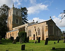
English: Knipton, is a small village in the English county of Leicestershire. It is located around six miles (9.6 kilometres) from the town of Grantham just off the A607, and ten miles (16 kilometres) from Melton Mowbray . Despite having a Nottinghamshire postcode, and Lincolnshire (Grantham) STD code, the village is located in the postal county of Leicestershire.
village in Leicestershire, UK | |||||
| Upload media | |||||
| Instance of |
| ||||
|---|---|---|---|---|---|
| Location | Belvoir, Melton, Leicestershire, East Midlands, England | ||||
 | |||||
Subcategories
This category has the following 2 subcategories, out of 2 total.
K
M
Media in category "Knipton"
The following 38 files are in this category, out of 38 total.
-
A fingerpost just north of Knipton, Leicestershire - Dec 2005.JPG 2,560 × 1,920; 5.04 MB
-
A road between Belvoir and Knipton, Leicestershire - Dec 2005 (1).JPG 2,560 × 1,920; 5.22 MB
-
A road between Belvoir and Knipton, Leicestershire - Dec 2005 (2).JPG 2,560 × 1,920; 5.09 MB
-
A view from the road between Belvoir and Knipton, Leicestershire - Dec 2005 (2).JPG 2,560 × 1,920; 4.17 MB
-
A view from the road between Belvoir and Knipton, Leicestershire - Dec 2005.JPG 2,560 × 1,920; 5.31 MB
-
Belvoir Road, Knipton - geograph.org.uk - 998921.jpg 640 × 427; 100 KB
-
Cottages on Pasture Lane - geograph.org.uk - 999278.jpg 640 × 427; 106 KB
-
Croxton Lane, Knipton - geograph.org.uk - 999327.jpg 640 × 427; 119 KB
-
Date plaque, Peacock Cottages - geograph.org.uk - 999298.jpg 640 × 614; 109 KB
-
Doe's in Knipton pasture - geograph.org.uk - 1306673.jpg 640 × 480; 88 KB
-
Farm building on Belvoir Road, Knipton - geograph.org.uk - 672928.jpg 640 × 427; 138 KB
-
Farmland near Knipton - geograph.org.uk - 999311.jpg 640 × 427; 109 KB
-
Knipton - geograph.org.uk - 999383.jpg 640 × 427; 104 KB
-
Knipton village hall - geograph.org.uk - 999056.jpg 640 × 427; 90 KB
-
Knipton, cottage in Croxton Lane (1) - geograph.org.uk - 1409942.jpg 640 × 480; 120 KB
-
Knipton, cottage in Croxton Lane (2) - geograph.org.uk - 1409944.jpg 480 × 640; 451 KB
-
Main Street, Knipton - geograph.org.uk - 999259.jpg 640 × 427; 91 KB
-
Main Street, Knipton - geograph.org.uk - 999267.jpg 640 × 427; 98 KB
-
Nursery Lane, Knipton - geograph.org.uk - 998914.jpg 640 × 418; 117 KB
-
On the edge - geograph.org.uk - 672700.jpg 640 × 427; 99 KB
-
On the way home - geograph.org.uk - 999409.jpg 640 × 427; 103 KB
-
Peacock Cottages, Pasture Lane - geograph.org.uk - 999288.jpg 640 × 427; 99 KB
-
The village pump in Knipton - geograph.org.uk - 27655.jpg 640 × 480; 167 KB
-
War Memorial, Knipton - geograph.org.uk - 999047.jpg 427 × 640; 136 KB
-
Belvoir Road - geograph.org.uk - 672956.jpg 640 × 427; 117 KB
-
Belvoir Road - geograph.org.uk - 672984.jpg 640 × 427; 94 KB
-
Branston Lane - geograph.org.uk - 672741.jpg 640 × 427; 119 KB
-
Countryside near Belvoir Castle - geograph.org.uk - 673000.jpg 480 × 640; 135 KB
-
Farm track near Branston - geograph.org.uk - 33918.jpg 480 × 640; 130 KB
-
Farmland near Knipton - geograph.org.uk - 672728.jpg 640 × 427; 109 KB
-
Farmland near Knipton - geograph.org.uk - 672874.jpg 640 × 427; 128 KB
-
Farmland to the west of Knipton - geograph.org.uk - 672975.jpg 640 × 427; 106 KB
-
Field and wood - geograph.org.uk - 673044.jpg 640 × 427; 86 KB
-
Knipton, Leicestershire - geograph.org.uk - 27651.jpg 640 × 480; 185 KB
-
Mole hills menace - geograph.org.uk - 299154.jpg 640 × 480; 158 KB
-
Reservoir Wood near Branston - geograph.org.uk - 67069.jpg 640 × 480; 138 KB
-
The River Devon at Knipton - geograph.org.uk - 672921.jpg 427 × 640; 136 KB


