Category:Klaus (storm)
Jump to navigation
Jump to search
English: This is a category containing media related to Klaus, a European windstorm that swept across France and Spain from the Bay of Biscay on 23-28 January 2009.
2009 windstorm over southern and southwestern Europe | |||||
| Upload media | |||||
| Instance of | |||||
|---|---|---|---|---|---|
| Start time |
| ||||
| End time |
| ||||
| Number of deaths |
| ||||
| |||||
Media in category "Klaus (storm)"
The following 51 files are in this category, out of 51 total.
-
 Bakio - Bermeo.jpg 1,024 × 481; 170 KB
-
 Barceloneta storm.jpg 3,072 × 2,304; 899 KB
-
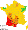
 Carte vigilance MétéoFrance 24-01-2009 06h00.svg 520 × 555; 311 KB
-
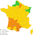
 Carte vigilance MétéoFrance 24-01-2009 08h10.svg 520 × 555; 377 KB
-
 Carte vigilance MétéoFrance 24-01-2009 10h44.svg 520 × 555; 356 KB
-
 Carte vigilance MétéoFrance 24-01-2009 16h00.svg 520 × 555; 331 KB
-
 Carte vigilance MétéoFrance 24-01-2009 20h11.svg 520 × 555; 308 KB
-
 Carte vigilance MétéoFrance 24-01-2009 22h13.svg 520 × 555; 256 KB
-
De-Klaus.ogg 1.8 s; 17 KB
-
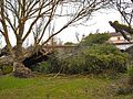
 Dégats.JPG 2,420 × 582; 492 KB
-
 España - Avisos Meteorológicos - 24-01-2009 - AEMET (fr).svg 705 × 455; 851 KB
-

-
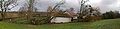
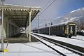 Gare de Luchon - François BOUF.jpg 3,072 × 2,048; 876 KB
-
 Garonne en crue - Tempête Klaus à Toulouse 01.JPG 3,072 × 2,304; 1.41 MB
-
 Garonne en crue - Tempête Klaus à Toulouse 02.JPG 3,072 × 2,304; 1.4 MB
-
 January 2009 Bay of Biscay storm tracker.png 650 × 500; 173 KB
-
 January 2009 Bay of Biscay storm tracker.svg 680 × 520; 530 KB
-
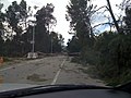
 Klaus (storm) on A63, France 1.JPG 2,560 × 1,920; 1.79 MB
-
 Klaus (storm) on A63, France 2.JPG 2,560 × 1,920; 1.41 MB
-
 Klaus (storm) on A63, France 3.JPG 2,560 × 1,920; 1.92 MB
-
 Klaus 23 January 2009.jpg 6,873 × 5,001; 6.21 MB
-
 Klaus storm track - 20090124 - map-ca.svg 2,000 × 1,922; 1.08 MB
-
 Klaus storm track - 20090124 - map-de.svg 2,000 × 1,922; 1.08 MB
-
 Klaus storm track - 20090124 - map-en.svg 2,000 × 1,922; 1.08 MB
-
 Klaus storm track - 20090124 - map-es.svg 2,000 × 1,922; 1.08 MB
-
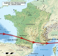
 Klaus storm track - 20090124 - map-fr.svg 2,000 × 1,922; 1.09 MB
-
 Klaus storm track - 20090124 - map-it.svg 2,000 × 1,922; 1.08 MB
-
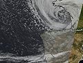
 KlausAnim 22-24.gif 642 × 500; 2.45 MB
-
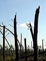
 La forêt des Landes après le passage de la tempête Klaus.jpg 1,440 × 1,080; 424 KB
-
 Ligustrum arrencat pel vent.jpg 576 × 768; 178 KB
-
 Marque laissée dans le bois par l'Armillaire.jpg 1,920 × 2,560; 1 MB
-
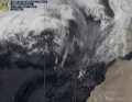
 MET9 20090123 1800Z WP.JPG 679 × 491; 32 KB
-
 Mungia - Bermeo.jpg 1,024 × 496; 489 KB
-
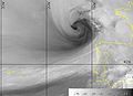
 NOAA18 20090124 0328H IR.JPG 425 × 326; 29 KB
-
 Saint Perdon bois.JPG 2,048 × 1,536; 607 KB
-
 San Juan de Gaztelugatxe.jpg 1,024 × 768; 544 KB
-
 St Pierre du Mont Klaus 1.JPG 2,048 × 1,536; 721 KB
-
 St Pierre du Mont Klaus 2.JPG 1,536 × 2,048; 420 KB
-
 St Pierre du Mont Klaus 3.JPG 2,048 × 1,536; 563 KB
-
 Temporal Euskadi 2009.jpg 1,024 × 573; 144 KB
-
 Tempête Klaus Mazerac 01.jpg 640 × 480; 351 KB
-
 Tempête Klaus à Fonbeauzard - 20090124 (1).jpg 3,072 × 2,304; 3.36 MB
-
 Tempête à Toulouse (24 janvier 2009) - Place Saint Etienne.jpg 1,024 × 685; 530 KB
-
 Trees & Streets (Valldoreix) 2.jpg 1,600 × 1,200; 454 KB
-
 Trees & Streets (Valldoreix) 3.jpg 1,200 × 1,600; 424 KB
-
 Trees & Streets (Valldoreix) 4.jpg 1,600 × 1,200; 392 KB
-
 Trees & Streets (Valldoreix) 5.jpg 1,600 × 1,200; 436 KB
-
 Trees & Streets (Valldoreix) 6.jpg 1,600 × 1,200; 414 KB
-
 Trees & Streets (Valldoreix) 7.jpg 1,600 × 1,200; 437 KB
-
 Trees & Streets (Valldoreix).jpg 1,600 × 1,200; 486 KB
-
 Uprooted trees near La Coruna January 2009.jpg 3,456 × 2,592; 5.48 MB


.svg)


_on_A63,_France_1.JPG)
_on_A63,_France_2.JPG)
_on_A63,_France_3.JPG)


.jpg)
_-_Place_Saint_Etienne.jpg)
_2.jpg)
_3.jpg)
_4.jpg)
_5.jpg)
_6.jpg)
_7.jpg)
.jpg)
