Category:Kilcoole
Jump to navigation
Jump to search
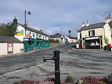
Български: 300px|мини|Изглед от село Килкул
Dansk: Kilcoole ( Irsk: Cill Chomghaill) er en irsk by i County Wicklow i provinsen Leinster, i den centrale del af Republikken Irland med en befolkning (inkl. opland) på 3.252 indb i 2006 (2.826 i 2002)
Deutsch: Kilcoole (Irisch: Cill Chomghaill) ist ein Dorf im County Wicklow, Ireland. Es liegt drei Kilometer südlich von Greystones, 14 Kilometer nördlich von Wicklow und rund 25 Kilometer südlich von Dublin. Der Ort wurde als Kulisse für die erfolgreiche irische Fernsehserie Glenroe genutzt, die in den 1980er und 1990er Jahren lief. Das Dorf ist zwischenzeitlich stark gewachsen und dient als Schlafstadt für zahlreiche Arbeitspendler, die in Dublin oder Bray arbeiten.
English: Kilcoole is a village located in County Wicklow, Ireland. It is three kilometres south of Greystones, 14 kilometres north of Wicklow, and approximately 25 kilometres south of Dublin. It was used as the set for the successful Irish television series Glenroe, which ran through the 1980s and 1990s. The village is currently expanding rapidly, and is a dormitory town for many workers commuting to Dublin and Bray.
Français : Kilcoole (Cill Chomghaill en irlandais) est une ville du comté de Wicklow en République d'Irlande.
Gaeilge: Cill Chomhghaill ( Béarla: Kilcoole). Sráidbaile i gContae Chill Mhantáin, Poblacht na hÉireann atá suite 3km dheas ón Bhaile Na Clocha Liatha. Rinne RTÉ an sraithclár Glenroe (An Ghleann Rua) timpeall an baile beag.
Nederlands: Kilcoole is een plaats in het Ierse graafschap County Wicklow. De plaats telt 3.252 inwoners.
village in Leinster, Ireland | |||||
| Upload media | |||||
| Instance of | |||||
|---|---|---|---|---|---|
| Location | County Wicklow, Leinster, Ireland | ||||
| Population |
| ||||
| Elevation above sea level |
| ||||
 | |||||
Subcategories
This category has the following 2 subcategories, out of 2 total.
K
- Kilcoole railway station (15 F)
Media in category "Kilcoole"
The following 29 files are in this category, out of 29 total.
-
Approaching Kilcoole - geograph.org.uk - 1582949.jpg 640 × 480; 107 KB
-
Ballydonarea Townland - geograph.org.uk - 1587024.jpg 640 × 480; 73 KB
-
Ballydonarea Townland - geograph.org.uk - 1587032.jpg 640 × 480; 81 KB
-
Beechwood Park, Kilcoole - geograph.org.uk - 1583073.jpg 640 × 480; 94 KB
-
Byrne's Pub, Kilcoole - geograph.org.uk - 1582985.jpg 640 × 480; 108 KB
-
Entering Kilcoole - geograph.org.uk - 1582898.jpg 640 × 480; 138 KB
-
Farmland east of Kilcoole - geograph.org.uk - 4072650.jpg 2,592 × 1,944; 1.41 MB
-
Irish Sea at Ballydonarea - geograph.org.uk - 1587180.jpg 640 × 480; 83 KB
-
Kilcoole Church - County Wicklow, Ireland.jpg 2,992 × 2,723; 6.97 MB
-
Kilcoole village - geograph.org.uk - 1583070.jpg 640 × 480; 107 KB
-
Kilcoole, County Wicklow - geograph.org.uk - 1583038.jpg 640 × 480; 92 KB
-
Kilcoole, County Wicklow, Ireland.jpg 3,024 × 2,966; 3.7 MB
-
Leaving Kilcoole - geograph.org.uk - 1583068.jpg 640 × 480; 98 KB
-
Main Street, Kilcoole - geograph.org.uk - 1582983.jpg 640 × 480; 124 KB
-
Main Street, Kilcoole - geograph.org.uk - 1583078.jpg 640 × 480; 96 KB
-
Neptune Cottage - geograph.org.uk - 1551645.jpg 640 × 480; 65 KB
-
New Road, Kilcoole - geograph.org.uk - 1583041.jpg 640 × 480; 121 KB
-
OldKilcooleParishPump5293.jpg 800 × 600; 90 KB
-
Road to Newcastle, Kilcoole - geograph.org.uk - 1587208.jpg 640 × 480; 87 KB
-
Roundabout in Kilcoole - geograph.org.uk - 1583035.jpg 640 × 480; 89 KB
-
Sea Road, Ballydonarea - geograph.org.uk - 1587018.jpg 640 × 480; 110 KB
-
Sea Road, Ballydonarea - geograph.org.uk - 1587020.jpg 640 × 480; 164 KB
-
Sea Road, Kilcoole - geograph.org.uk - 1587011.jpg 640 × 480; 109 KB
-
Sea Road, Kilcoole - geograph.org.uk - 1587014.jpg 640 × 480; 104 KB
-
Sign, New Road, Kilcoole - geograph.org.uk - 1583054.jpg 640 × 480; 157 KB
-
The R761 approaching Kilcoole - geograph.org.uk - 4072655.jpg 2,592 × 1,944; 1.05 MB
-
The R761 leaving Kilcoole - geograph.org.uk - 4072644.jpg 2,592 × 1,944; 1.34 MB


