Category:Kelbaker Road
Jump to navigation
Jump to search
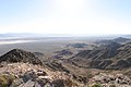
{{en|1-The Kelbaker Road is a rural back country desert road that travels through the Mojave Desert in San Bernardino County, Southern California.
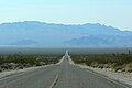
- The southern terminus of the road begins off U.S. Route 66 between Amboy and Chambless; and continues north-northwest through the Mojave National Preserve past Kelso; to reach its northern terminus at Baker, on Interstate 15.
- The name "Kelbaker" is a portmanteau of "Kelso" and "Baker", the two settlements located along the road.
| Upload media | |||||
| Instance of | |||||
|---|---|---|---|---|---|
| Location |
| ||||
| |||||
Media in category "Kelbaker Road"
The following 15 files are in this category, out of 15 total.
-
 Kelbaker Road.jpg 2,000 × 3,008; 5.07 MB
-
 East Bristol Mountain, Amboy CA - panoramio.jpg 3,072 × 2,048; 845 KB
-
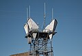
 East Bristol radio site - panoramio.jpg 1,024 × 682; 201 KB
-
 Joshua Tree National Park Sign - Route 66 (28276060424).jpg 5,760 × 3,840; 21 MB
-
 Kelbaker Road approaching Baker.jpg 1,800 × 1,200; 308 KB
-
 Kelbaker Road Southern California (28893392625).jpg 5,009 × 3,146; 8.18 MB
-
 Kelso Depot 1.jpg 1,800 × 1,112; 356 KB
-
 Kelso from Kelbaker Road 1.jpg 1,800 × 1,200; 430 KB
-
 Kelso Mountains 1.jpg 2,400 × 1,600; 581 KB
-
 Microwave tower in the Mojave National Preserve, California (28795031790).jpg 4,990 × 3,395; 7.72 MB
-
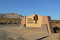 Mojave National Preserve sign 1.jpg 2,400 × 1,600; 624 KB
-
 Red barrel cactus, in Lava field off Kelbaker Road.jpg 5,271 × 3,514; 13 MB
-
 Van Winkle Mountain 1.jpg 2,400 × 1,600; 654 KB
-
 Van Winkle Mountain 2.jpg 2,400 × 1,600; 708 KB
-
 Willow Wash at Kelbaker Road.jpg 2,400 × 1,600; 668 KB


.jpg)

.jpg)


.jpg)


